
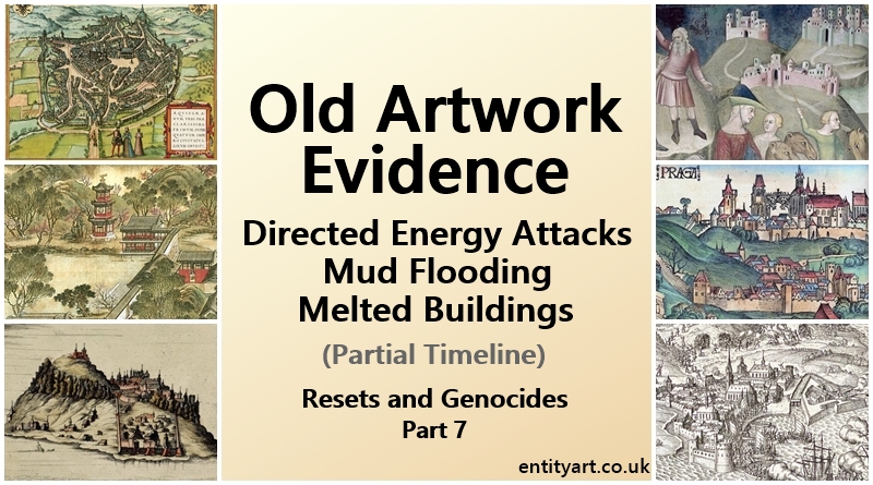
Old Artwork – Drawings and Maps – Old World Cities – Partial Timeline – incl. ‘Star Forts’. Resets and Genocides, Part 7
(Part 7 of a 14 Part Series)
Sections:
- Introduction
- Establishing the Old World Cities Layouts and Depth
- Large Walls, Deep Buildings and Castle complexes
- Old World Towns and Cities – Walls, Star Fort Walls and Canals
- 14th century European Art
- 15th century European Art
- 16th century European Art
- 17th century European Art
- Comparisons: Monemvasia Island, Greece – Palanok Castle, Ukraine – Milan, Italy – St Petersburg, Russia
- Asian Art in the 1700s (India, China, Japan, Myanmar)
- Tartaria and North Africa Artwork Reminders
- European ‘Colonies’ – Australia, New Zealand, South Africa + North and South America
- Jamestown
- New World Explorers’ Illustrations
- Religion – Dates
- Concluding Thoughts
Additional Images:
- Star Fort Distribution Map (Atlantis)
- Nuremberg Chronicles Maps Gallery
- Additional Images from 1500s, 1600s and 1700s
- Saint Malo Case Study
- ‘Star Forts’ Then and Now
- More ‘Star-fort’ maps
Introduction:
We have established – from both the previous ‘Mud Floods’ article and ‘Our World in Ruins / Melted Buildings’ article (Parts 5 and 6 of this series) – that both mud flooding, and the melting of buildings occurred. So now we can start looking into when it likely occurred. Both these effects could have occurred from the same technology, and from the same targeted events… but there is also the possibility that perhaps the melting occurred first and then mud flooding came not long after.
Before we look at old artwork, we need to establish what all these Old-World cities might have looked like originally. Including both the depth of the buildings and the layout of the cities. In this article we focus on the White giants Old World buildings, but there is also a section containing some old art from China, Japan and South Asia.
I did consider placing this article after Part 8 of this series – which is about the technology and knowledge utilised by the Old-World builders when constructing their energy harnessing, connected networks of cities – as you might get a better feel about how elaborate and complex they were – and you would perhaps see more clearly how much destruction has taken place. But it is also useful to have this current article straight after the mud-flooding and melted-buildings articles. So, I would suggest re-visiting this article after you have read Part 8. For now, I will create an opening section for this current article that helps you to see some of the significant features of the various Old World cities that have been partially destroyed, as well as how much they may be buried and or melted.
Below, we will look at some artwork and city maps from the 15th, 16th, 17th and 18th centuries – as well as a little from the late 14th century. We will see that the bulk of this ‘shaping of the world’ almost certainly occurred more than 500 years ago – the mud flooding, melting of buildings and shaping of landscapes (Unfortunately, there is no useful artwork beyond the very late 1300s, which is very telling in itself). Many events have happened since the first severe ancient resets – there has been an incremental, more subtle, continuous destruction of Old World buildings since then, but the bulk of the destruction very much looks to have occurred a long time ago. In fact, I would suggest the bulk of the destruction occurred a lot further back than 500 years ago – a lot of it very likely occurred back before some of the religions were invented.
In the old artwork we can see a lot of evidence of both melted buildings and mud flooding.
Establishing the Old World Cities Layouts and Depth
Before we look at the old illustrations and paintings, we will look at how large and deep the Old World cities surrounding walls could be – it is very likely that all Old-World cities always originally had a tall, thick wall surrounding them. Then we will look at the castle mounds and their spiralling walls, and then briefly re-visit how deep Old World buildings can be. In a following section we also establish the city layouts and the ‘star fort’ walls and canals that were used in and around the city’s and towns. All this is important to help you with your analysis of old artwork from the late 1300s to the mid 1700s.
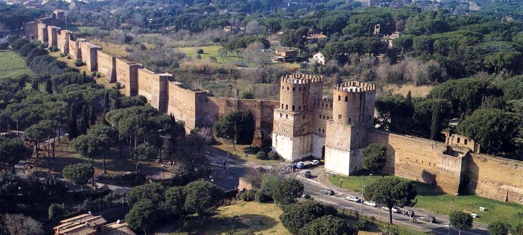
Large Walls, Deep Buildings and Castle Complexes:
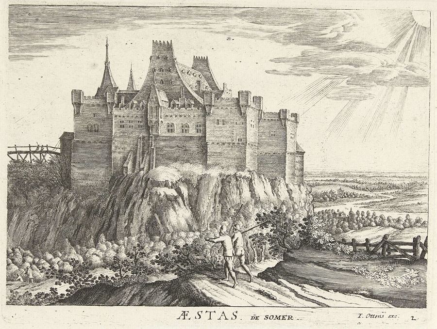
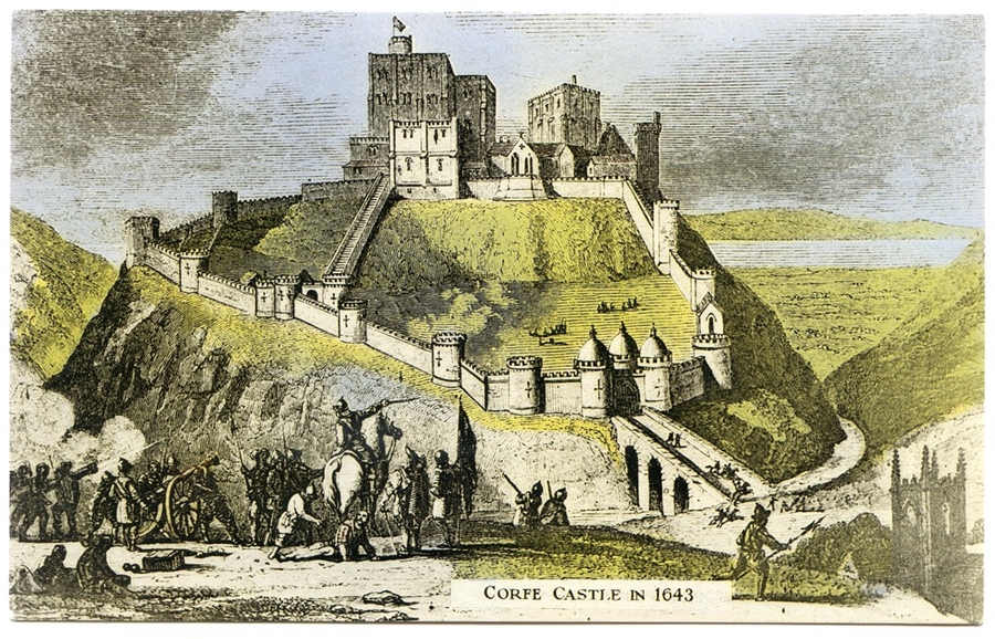
The castles in the city, or in the surrounding areas of the city, would have often been huge complexes, with many parts to them. Many tall walls and surrounding buildings, and various towers attached – and usually the main building was taller than the rest of the attached buildings and was on top of the mound.
Castle Mounds:
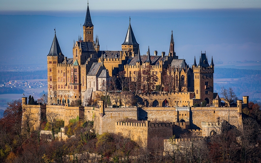
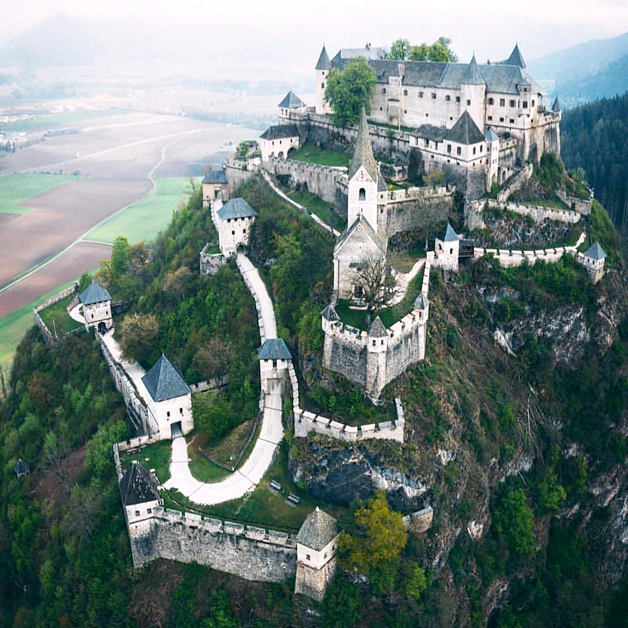
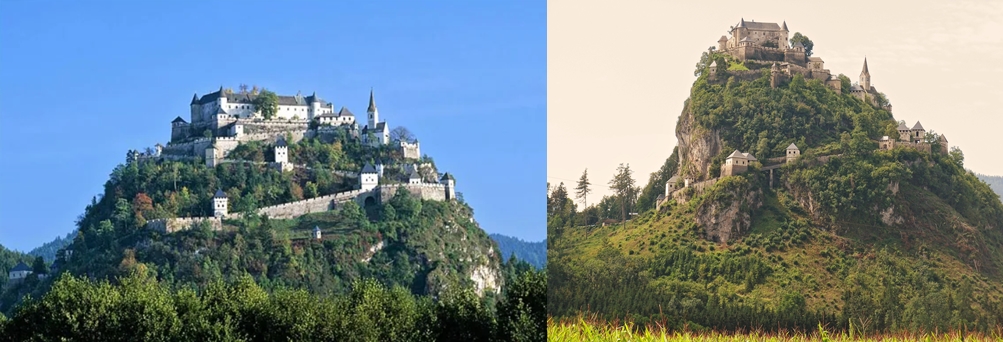
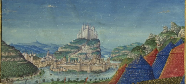
Image above: These castle mound walls and buildings would have spiralled all the way down to the bottom of the hill – to ground level. Many layers of walls – in stages – spiralling up the mound. And these areas between walls would not have been filled in with dirt. This would have been the case for all castle mounds.
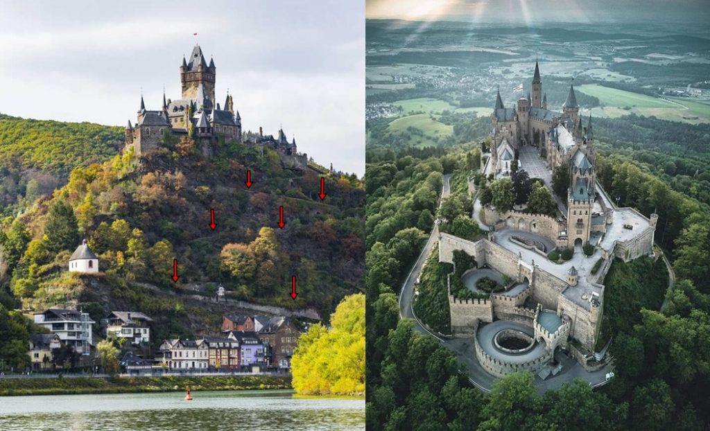
At the top of Hohenzollern Castle above, we just see the beginnings of the spiralling walls that would have spiralled all the way to the bottom of the hill / mound. You can find remnants of these spiralling castle walls on many castle mounds.
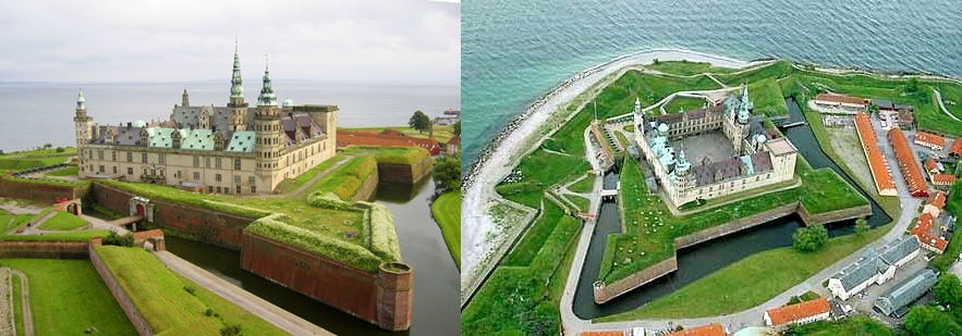
Tall Surrounding Walls:
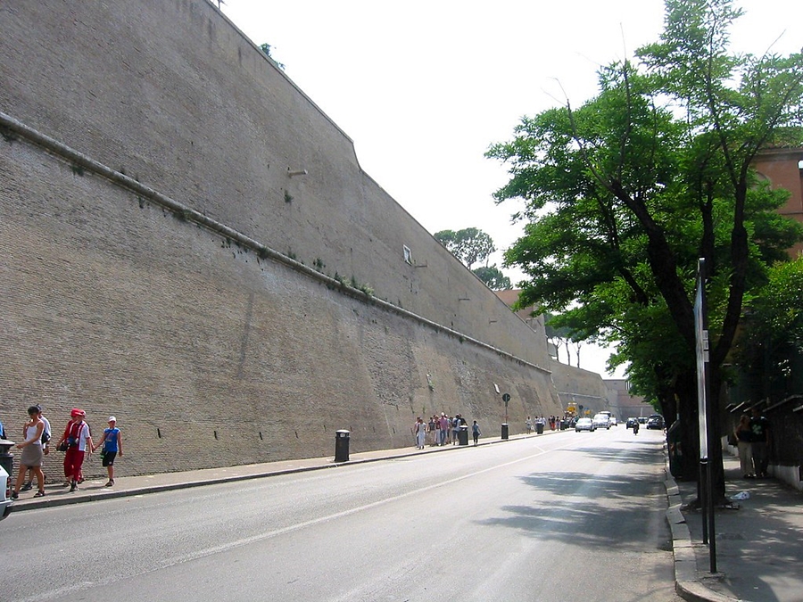
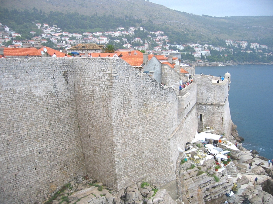
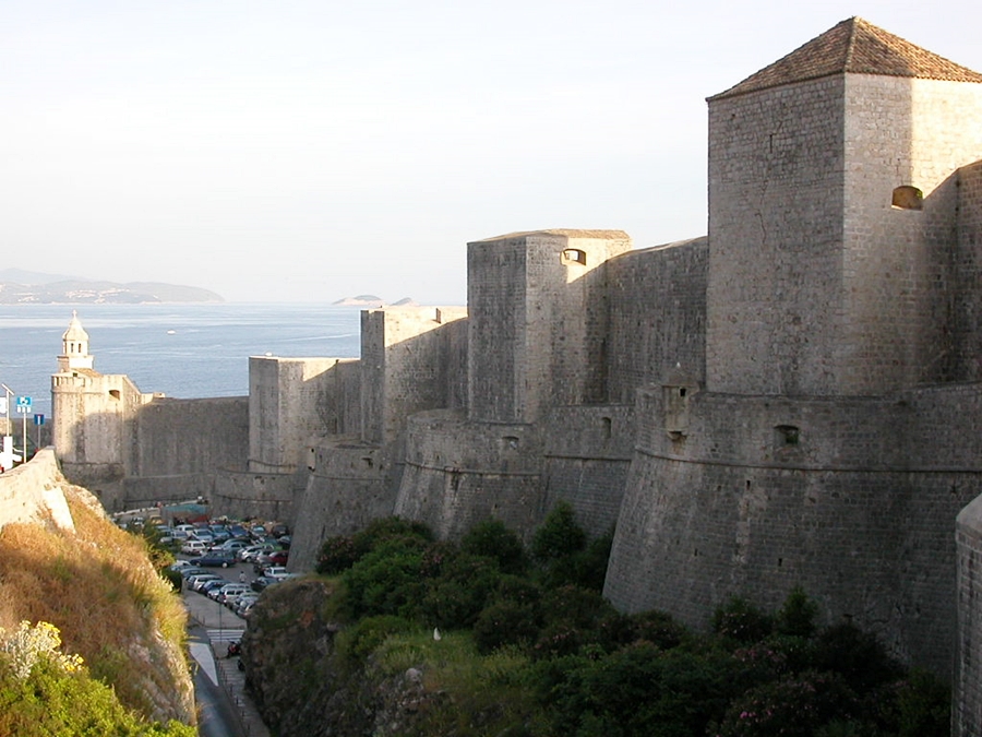
Deep / Tall Buildings:
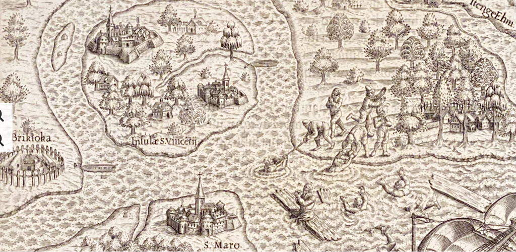
Old World Town and City Layouts – ‘Star-forts’ and Canals:
As will be discussed in greater detail in the next article on Old-World technology (Part 8 of this series), the cities of the Old-World civilisation were all linked by canals. This very much seems to be the case for the White giants, who extensively used canals and ‘star fort’ walls in their civilisation / civilisations. It is likely that all of the White giants canals were linked in a huge network. The ‘star fort’ canals surrounding the city had regular canals and rivers leading to them from other towns and cities – however, as the land has been shaped and destroyed so much by the invaders, we cannot say that every single city had them with certainty, but definitely the vast majority (very likely all of them). The long, city connecting canals also sometimes used aqueducts (more on that in Part 8).
Water was SO important to the people of the Old World. As mentioned, all cities would have water encircling it – sometimes with various layers of canals and walls. But cities also often had huge underground (giant made) rivers and large (giant made) reservoirs of water under certain areas of the city (Shown in Part 8 of this series). Many cities also had large rivers or canals flowing through their centre.
The ‘waterways’ were originally not for transportation of goods or for leisure purposes, their primary use was for energetic purposes. We know from the information in my Atlantis article on this website that water can be energised and structured – it can hold energy beneficial to the human body.
You will see these connecting rivers and canals in the ‘star city’ / ‘star fort’ maps below (Much more on water use in Part 8 of this series).
Star Forts
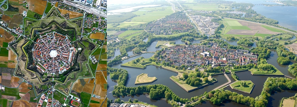
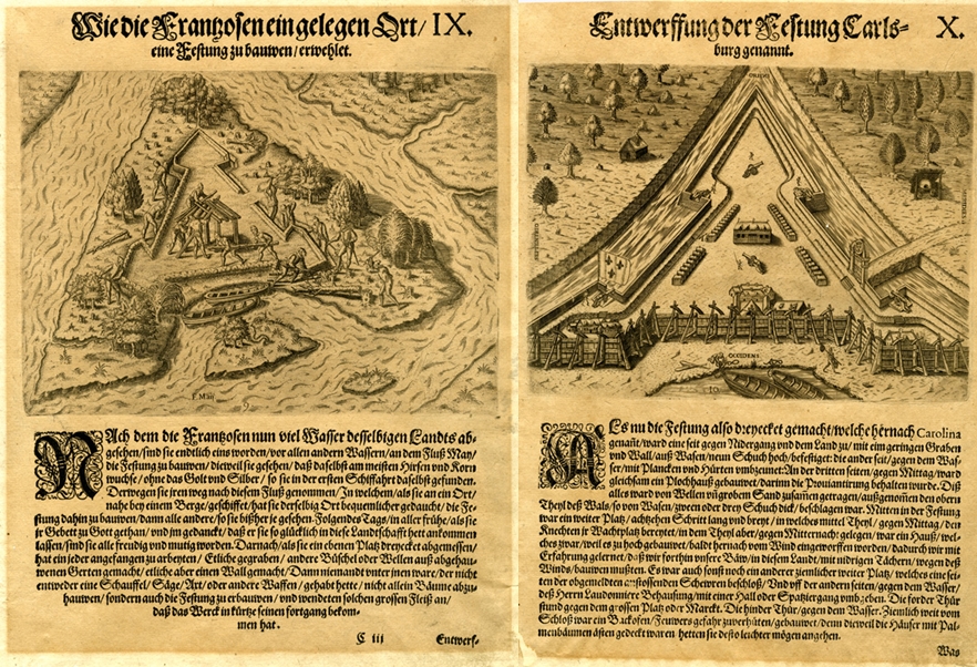
‘Star-fort walls’ and ‘star-fort canals’ were a huge part of the Old World civilisation. It was a building technique used by the Old World, White (Caucasian) civilisation. ‘Star fort’ walls are the jagged / pointed wall arrangements outside a settlement or city, which also have water inbetween the walls.
There is plenty of evidence for their existence in aerial photos of small settlements in Europe. There is also evidence for them if you look at old city maps from the 1500s and 1600s.
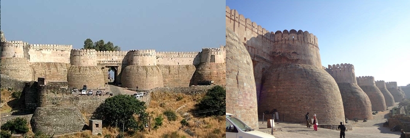
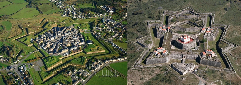
‘Star fort’ arrangements around Smaller Settlements or Small Towns:
Photos of partially surviving ‘star fort arrangements. Note that not all layers may be visible, some canals and walls may be missing. All canals between the star walls would have originally had water in them.
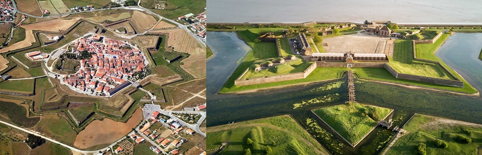
Important note: These are not ‘forts’. ‘Star forts’ is just the subversive name given to these architectural techniques / arrangements. But this is how people refer to them now. They were not originally built for war and defence, but for energetic purposes. Very likely to harness, amplify and move the beneficial electric cosmic energy – which comes to us from our electric Sun – so as to bathe the people living inside the ‘star walls’ and ‘star canals’ in this beneficial energy. More on the energy harnessing aspects on these Old-World cities in Part 8 of this series.
The rhetoric about them on-line is obviously nearly always subversive and what even the alternative media do not tell you is that these jagged / pointed ‘star’ walls were also around all the large cities as well, as demonstrated below.
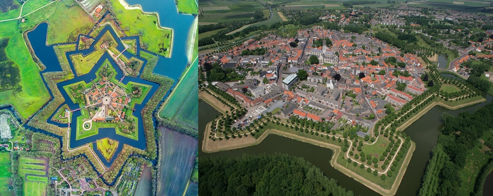
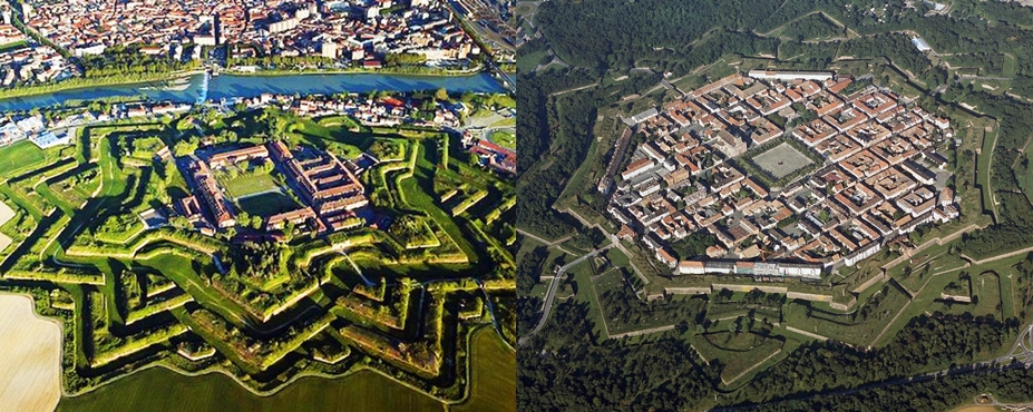
The smaller settlements tended to be more elaborate with many layers of ‘star-fort’ walls, the cities (larger settlements) ‘star-fort’ walls were usually less complex, but they also had these jagged / pointed ‘star fort’ walls and star-fort canals.
These ‘star fort’ walls / canals are nearly all gone from the main cities of the world now (just small remnants if you look carefully), but you can see them more clearly around some isolated small towns / settlements of the world – not many, but there are still some.
Some sort of ‘star-fort’ arrangement would have very likely been around every city, town, or small settlement in the Old World White (Caucasian) civilisation. They were very focused on living in areas with high amounts of beneficial energy.
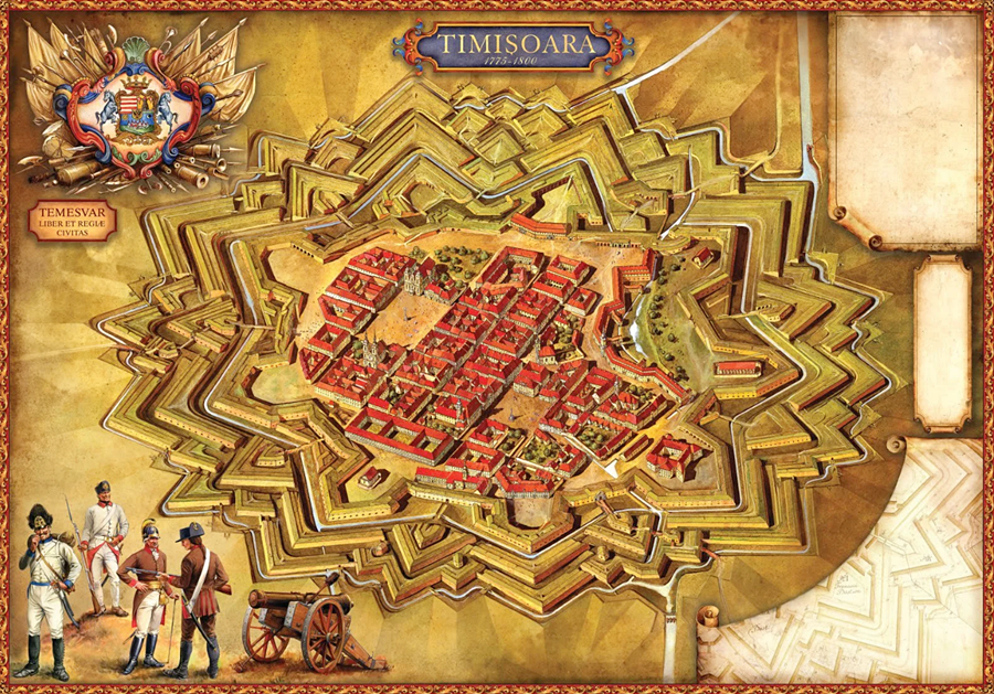
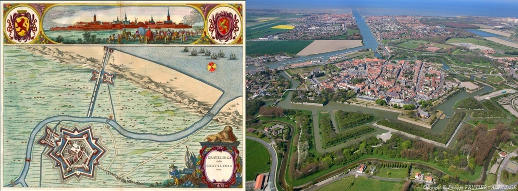
Map of Timisoura:
(A complex ‘star-fort’ arrangement around a smaller settlement)
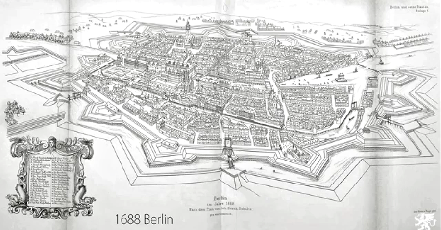
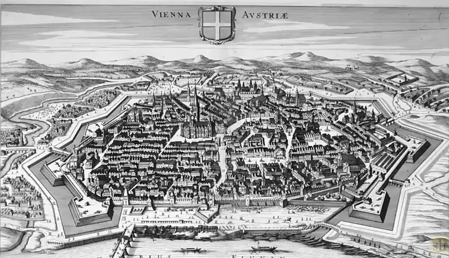
‘Star’ fort’ Walls and Canals around Cities:
Below are some maps from the 1500s and 1600s, showing the ‘star fort’ wall / canal city layouts, as well as the canals and rivers going to and from the surrounding city canals.
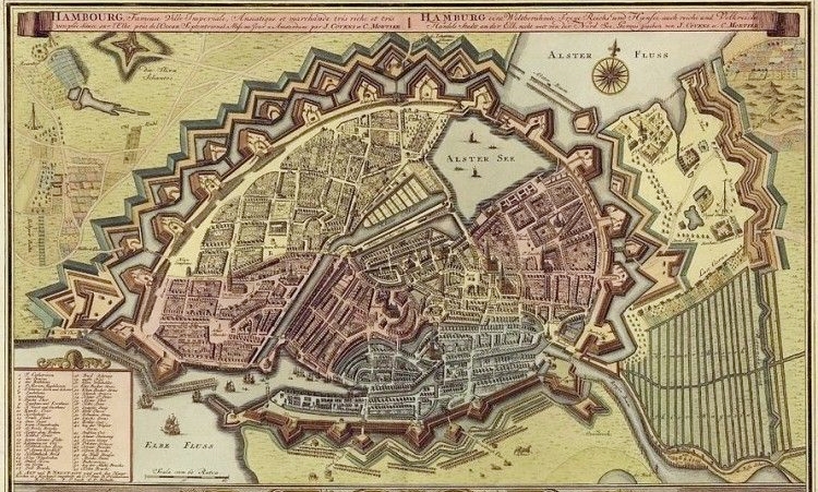
The Hamburg map above is showing various layers of ‘star fort’ walls.
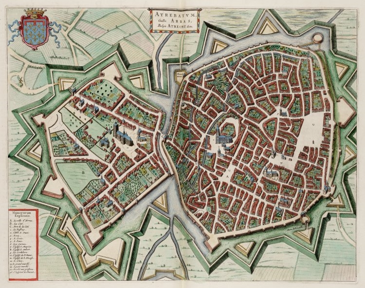
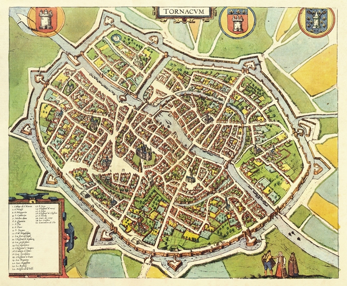
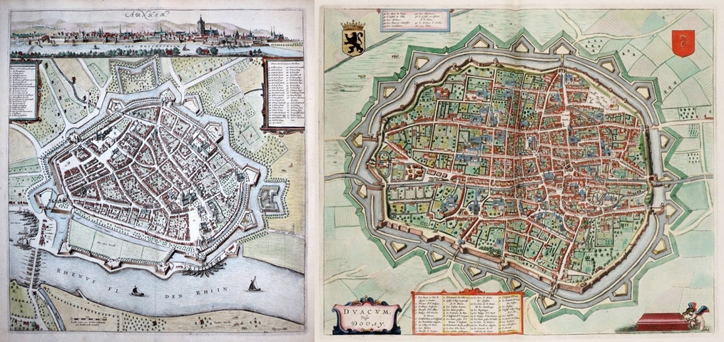
Douai above, is showing two layers of canals and walls beyond the city walls.
Illustrations of Cities and Large Towns with ‘Star-fort’ Walls and Canals:
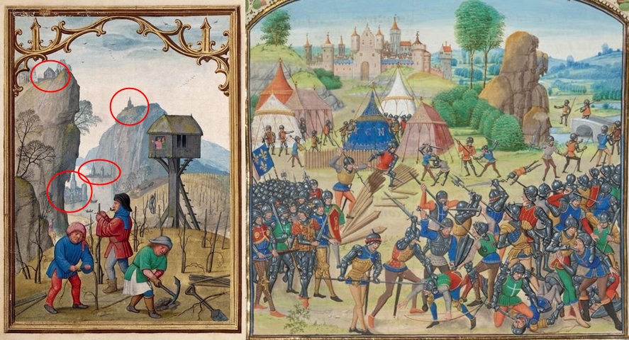
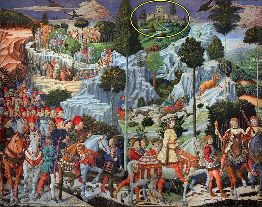
Interesting note: In the image above, in distance you can see the names of small settlements on the top of hills, and you can also see the buildings of the small settlements. If you were taking notice during the melted buildings article you would realise that these settlements are what remain of melted buildings / castle mound complexes. We are just seeing the top part of a complex on the top of those distant ‘hills’ / mounds.
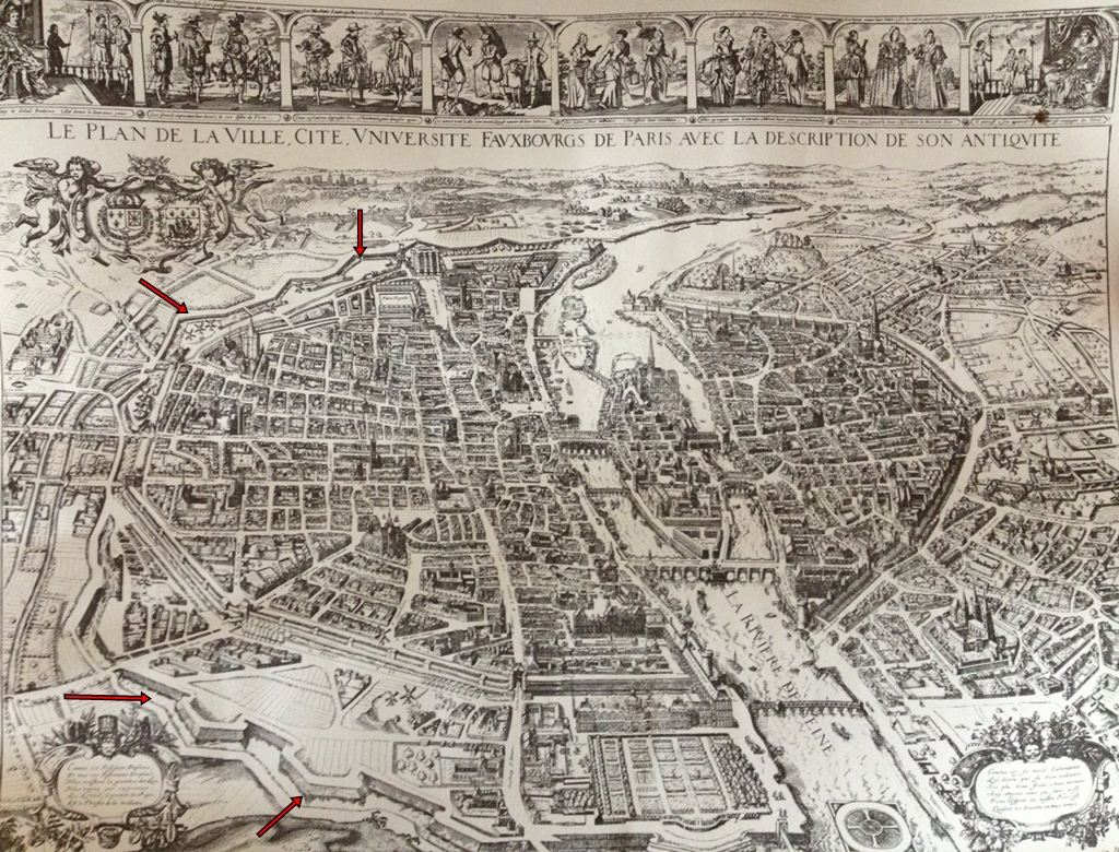
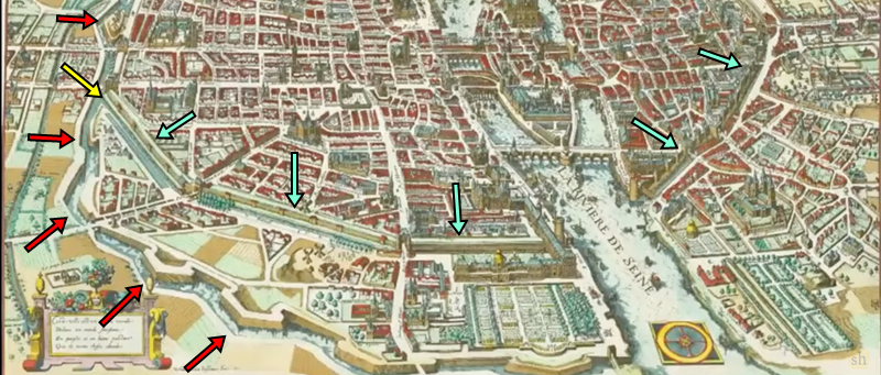
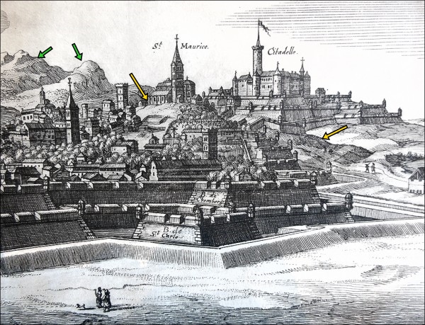
Above Image: I have added yellow arrows to show mud flooding (raised mounds of ground inside the city and near the walls of the city). As well as green arrows pointing to hills that are very likely not hills, but destroyed / melted buildings.
Important note: These Old-World Builders were experts – incredible builders – who planned well ahead and who greatly utilised water flowing around and through the cities. They would have definitely flattened the ground inside the town or city, and in the surrounding areas of the town or city, before building it. Water was so important to these Old World buildings – water had to flow into, and out of, the cities surrounding canals. You are not going to have messy and bumpy land in and around these towns and cities.
It seems most ‘star-fort’ walls and their canals were destroyed by the 1500s (Likely much earlier than this, but we don’t have the necessary records or artwork, which again, is very telling), and then the ones that had survived also eventually ‘disappeared’. It was important to establish what the cities would have looked like originally, and some of these images above will have greatly helped with that. Now we can go through artwork / drawings / maps from the different centuries, analysing some of the images.
In some old art you can see small remnants of these ‘star fort’ walls and the canals that ran around the city. But in some you cannot see the pointed ‘star fort’ walls at all, but just a large body of water or small undulating hills surrounding the city walls. Look out for both mud flooding and melted buildings.
Note: Don’t miss the ‘Star Forts’ Then and Now comparison images in the Additional Information Section at the end. Some interesting images.
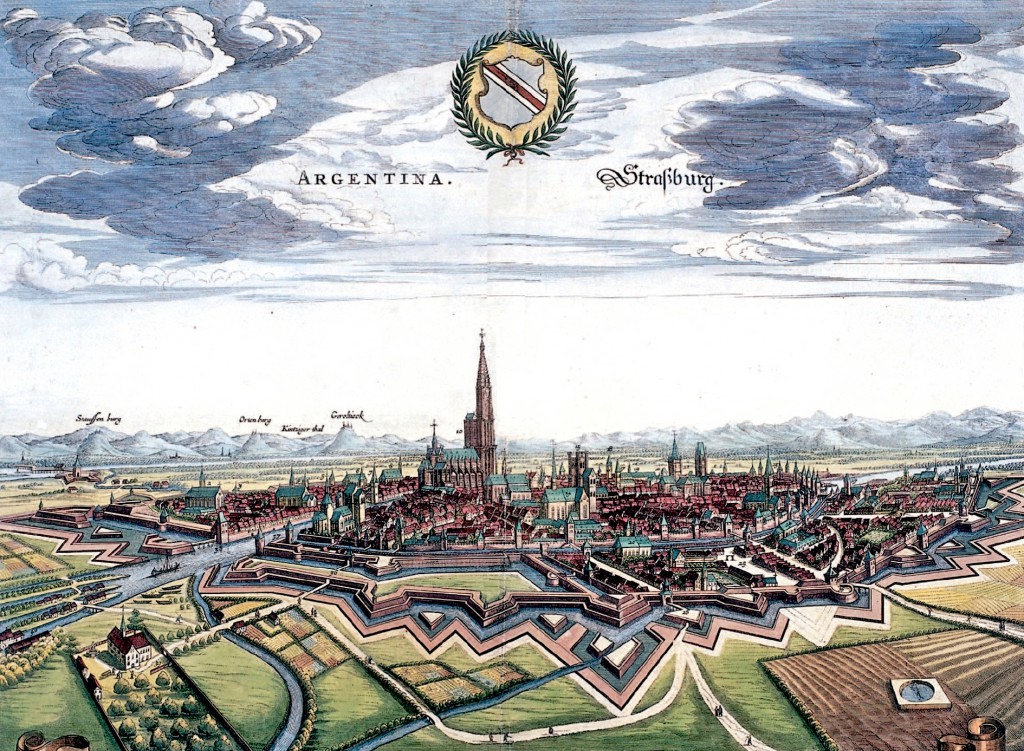
Old European Art
Note: You have an opportunity to here to really start looking carefully at old art and analysing it. Keep your eye out for partially melted buildings, melted landscapes, strange ‘rock formations’, missing city walls, missing star-fort walls, missing canals, mud flooded buildings, mud flooded cities, partially destroyed castle mounds, partially destroyed building complexes and small remnants of buildings.
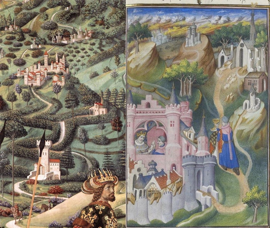
1300s
I sometimes highlight certain areas in the painting or sketch, but sometimes I just leave it up to the reader to observe the evidence in the images.
There is not a lot of surviving art from the 1300s – most useful artwork in this century will be from the late 1300s (These images below are from the late 1300s). It was surprising to me how little artwork there was available to view before the 1400s – and even more so before the 1300s – there were no useful maps or illustrations of cities, which is very telling and alludes to another reset of sorts.
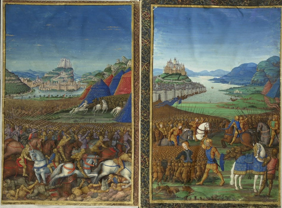
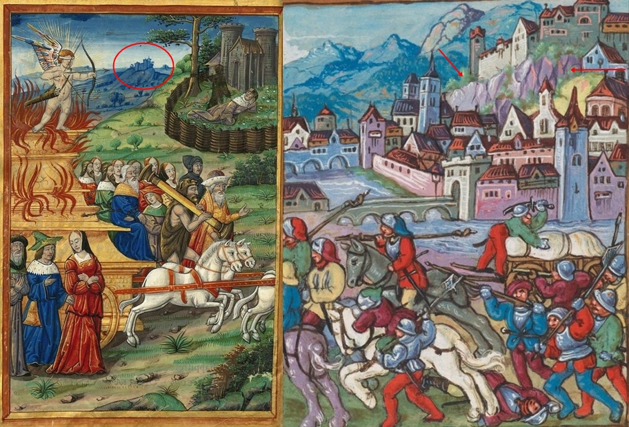
These images below are difficult to date. They are illustrations in a book created by Guido Delle Colonne, which describes the destruction of Troy. (He was said that have lived from around 1215 to 1290- some places say he died a bit earlier than this). These Illustrations below – which are depicting the famous battles in and around Troy – were used in a translation of this work that was said to be published in 1475. The images would be based on earlier descriptions of the battle that Guido had access to, but would also be influenced by what that artist has seen in his everyday reality. They show melted buildings and mud flooding with the outer canals and layers of walls gone. They also showed the city surrounded by water:
1400s
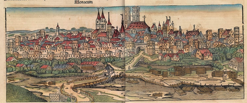
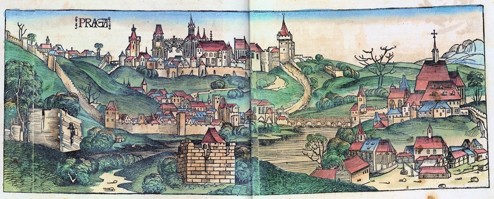
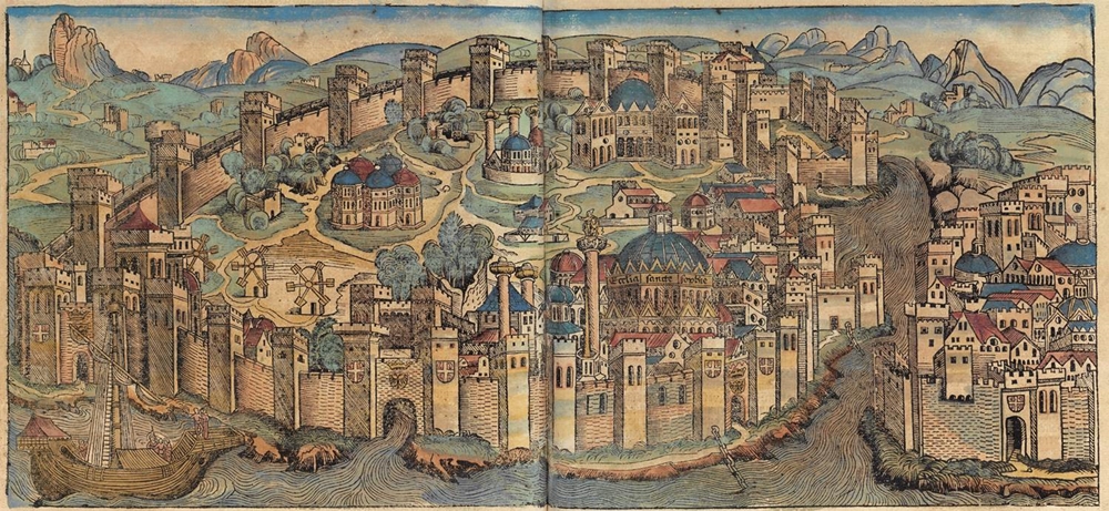
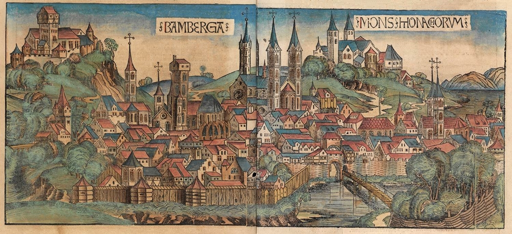
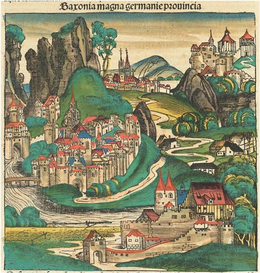
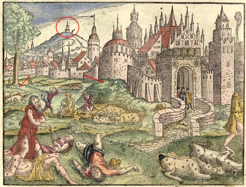
In the 1400s The Nuremberg Chronicles were created – and in it there were maps of cities from around the world. They are not going to be perfectly accurate of course. But you will see clearly that the melting of buildings and the destruction of canals, and the layers of star-fort fort walls, had occurred before this work was created. It also looks like there has been a good amount of mud flooding. Here is a small selection of of these drawings. There are more of these Nuremberg Chronicle maps, from other locations, in a gallery in the Additional Images section at the end of the article. All images were published in 1493:
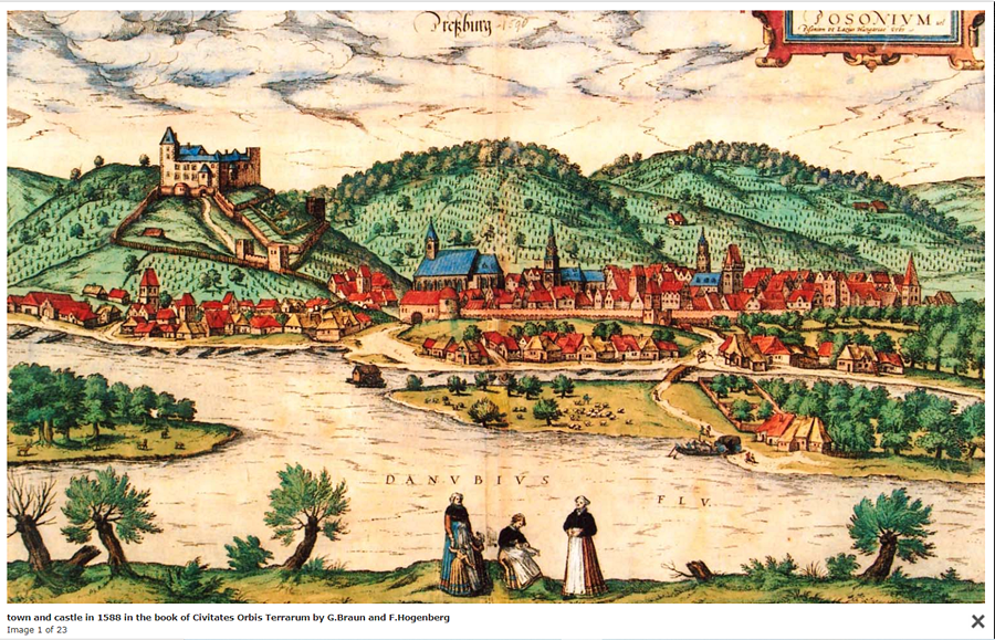
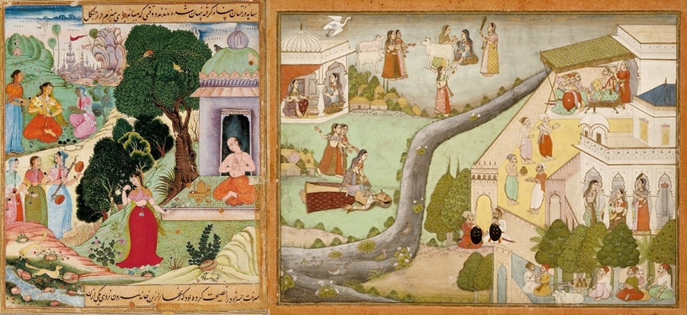
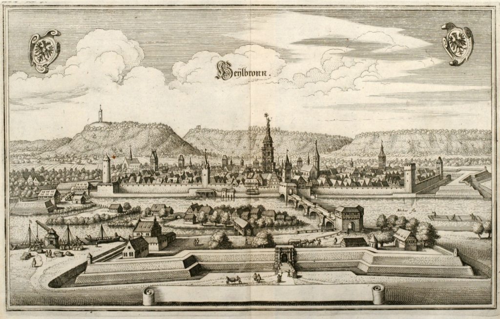
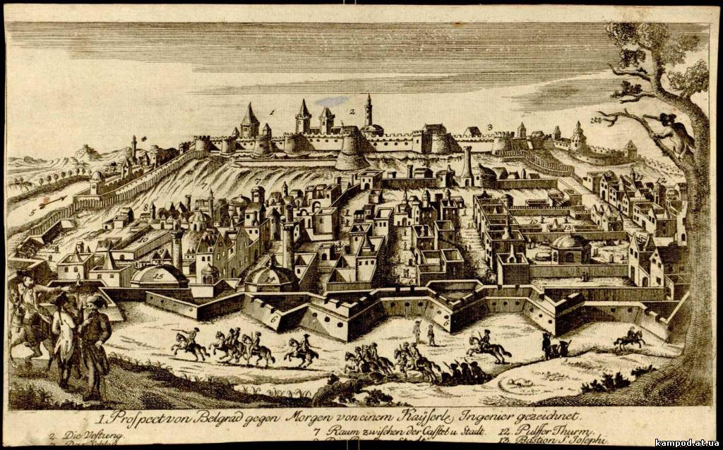
1500s
1600s
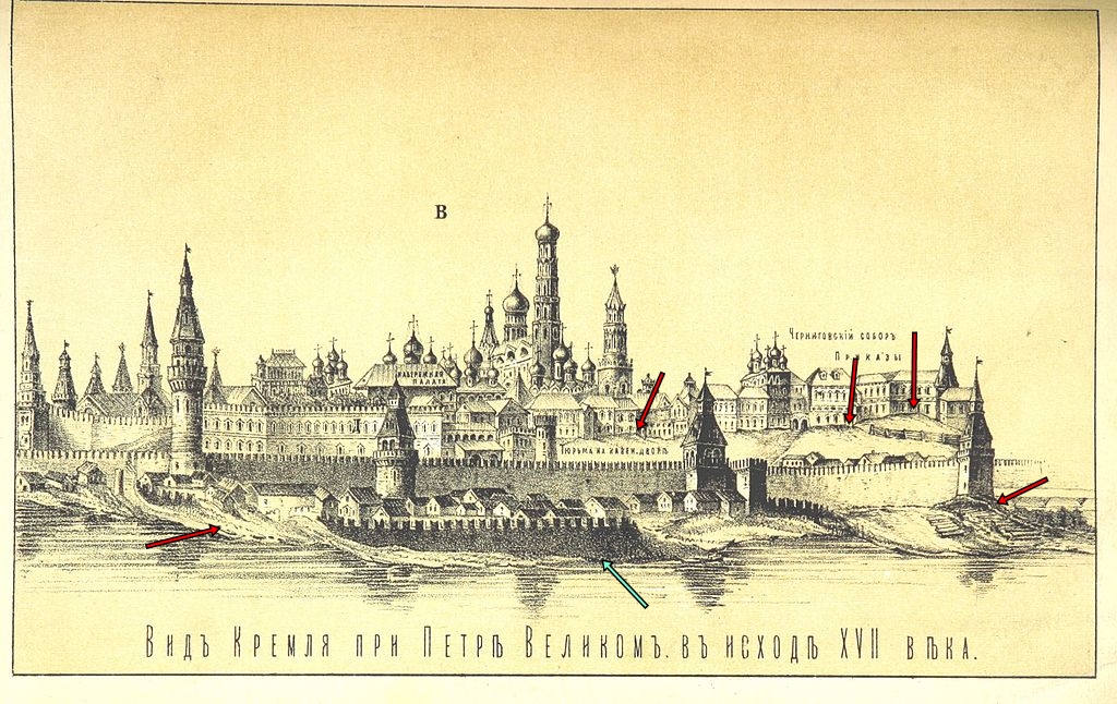
In the image above of the Kremlin I have pointed out the areas of mud flooding, as well as the partial wall in front of the larger wall behind. There would have likely been numerous layers of walls – likely some star fort walls as well – extending into that river… it has all been destroyed. The areas inside the city would have been level, and the ground level much lower. There would not have been these mounds of earth / mud that we can see inside the city walls.
Above image: Light blue arrows point to the melting of structures. In this body of water at the front of the map there would have been ‘star-fort’ walls – you can see one layer of surviving ‘star-fort’ / city walls on the right of the image and a canal beyond it. The yellow arrows point to towers that would have been connected to large structures and a series of walls and canals. Red circles in the background highlight all the large castle-like mounded complexes, that have been partially destroyed and melted, with just the top of the building complex sitting on top the large ‘hill’ / mound.
Comparisons
Monemvasia Island, Greece:
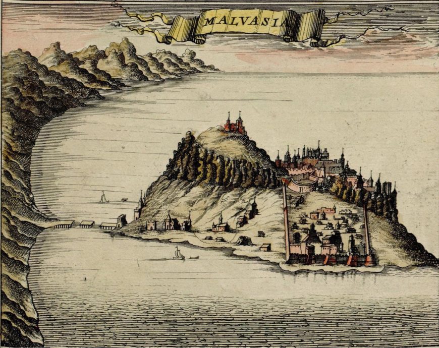
Above Image: We can see a lot of evidence of melted buildings, with that messy bumpy rock around the remnants of the city and one building at the very top of a bumpy mound. This Island would never have looked like this originally – it is a mess. Lots of partially buried buildings and pockets of surviving architecture dotted around. But we can still see an Old-World town on the top, on the right side of the mound.
Today all these Old-World buildings have gone from top of the mound / hill, completely gone! So we know there have been further attacks here since 1680. What can obliterate a town of large Old-World stone buildings like that?
Mukachevo, Ukraine – Palanok Castle:
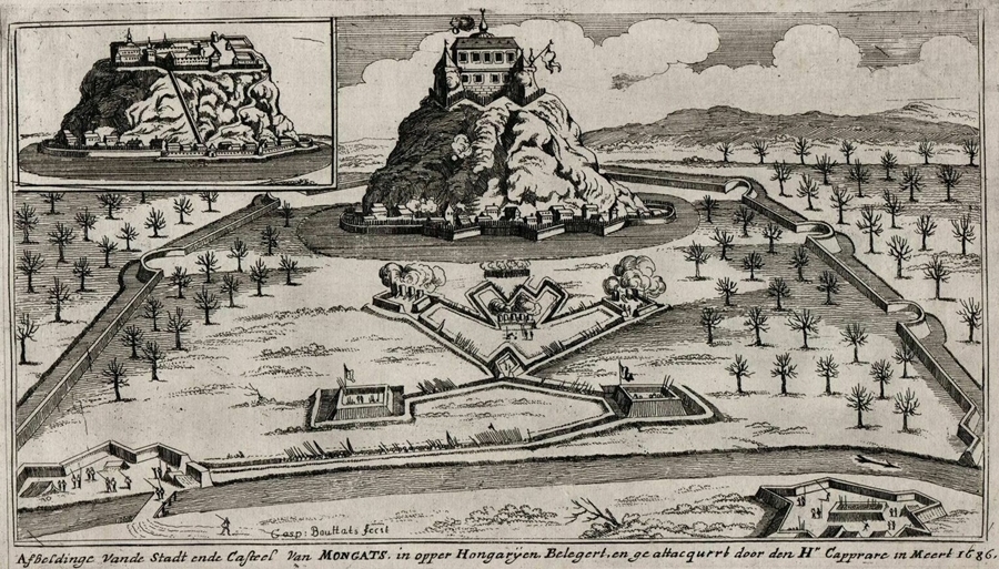
Above you can see that the main mounded building complex has been partially melted and destroyed. Originally, a castle mound like this would have had layers of walls and buildings all the way down to ground level – it would not be a mass of bulging rocks with a building on top. The large area of flat ground inside the outer walls would have surely had various structures on it – now it just has trees. The canal arrangement in the centre of the walled flattened area is interesting and would have had some sort of energetic purpose… water was likely inside that strange arrangement of canals at some point.
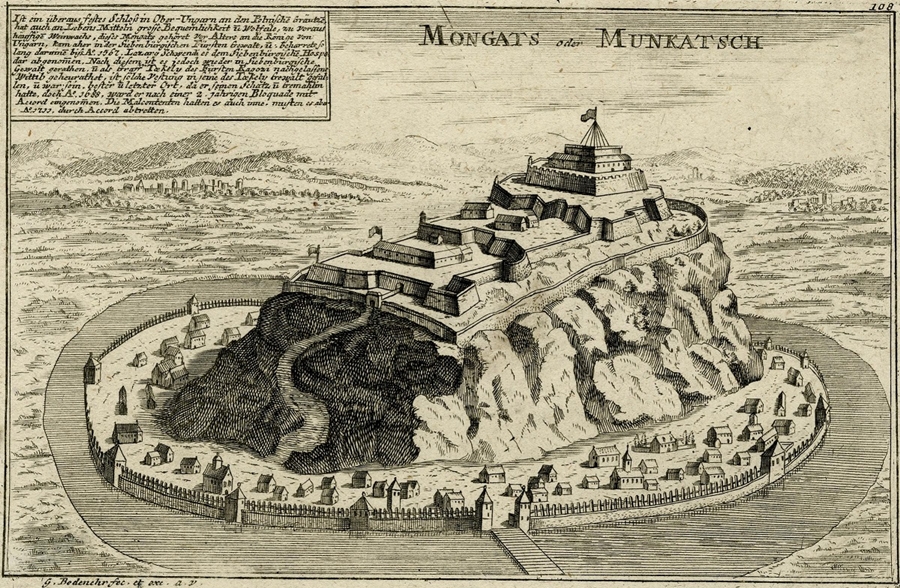
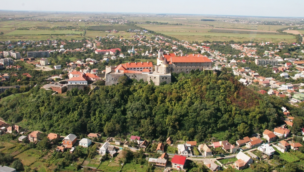
No water or walls anywhere to be seen!
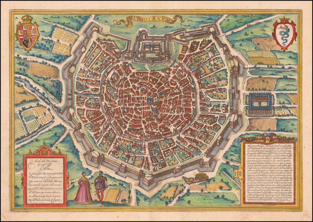
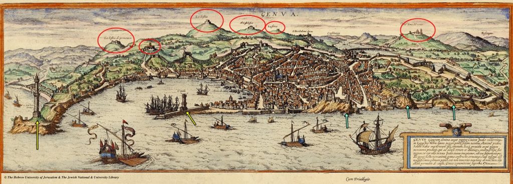
Milan, Italy:
Image above: These surrounding walls would have been very tall, we can see the size of them by comparing them to the old world buildings in the map. Think back to the tall walls I presented in an earlier section.
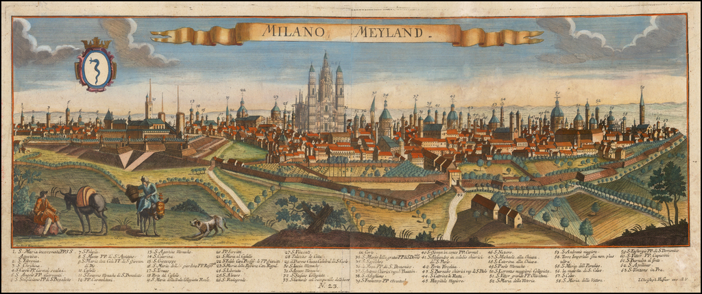
We can see that the large channel of water encircling the city has completely gone and you can barely see the large / tall star-fort walls anymore. The remaining areas between the ‘star fort’ walls and the city have been filled with dirt.
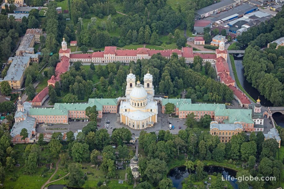
St Petersberg
Some Old-World Buildings of St Petersburg, Russia – comparisons to old artwork.
Below is clear evidence that St Petersberg has not been mud flooded since 1755 – if it was, they cleared it all away very quickly without any damage to buildings!
Many so-called ‘mud flood’ ‘truthers’ claim St Petersburg was engulfed in this ‘worldwide mud flood’ in the 19th century. But it was not. There was no worldwide ‘mud flood’ in the 19th century. To create the 1800s reset it has been a systematic targeting of specific areas, at specific times, in the the 1600s, 1700s and 1800s with various types of reset related disasters or ‘events’.
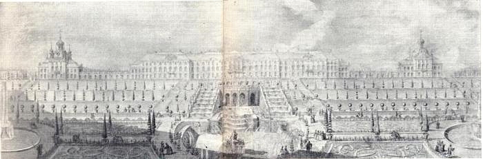
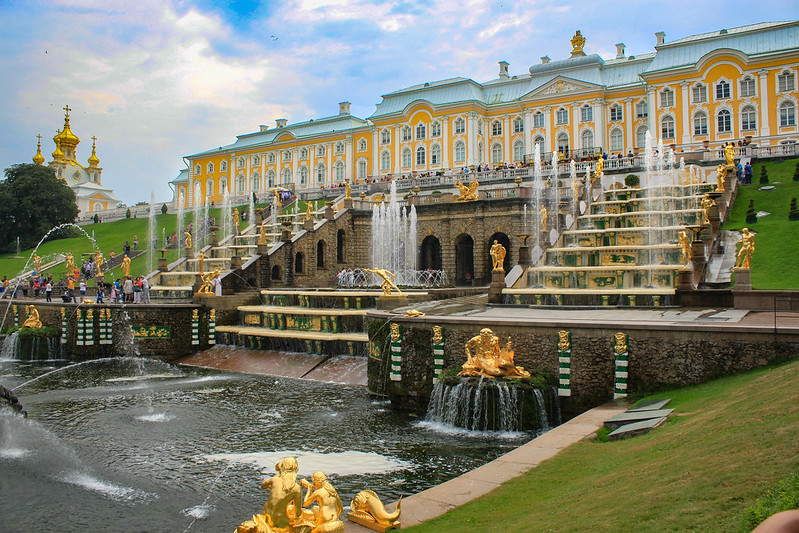
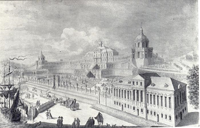

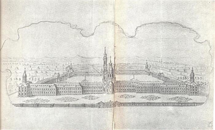
All three huge Old World buildings are currently at the same depth that they were in 1755.
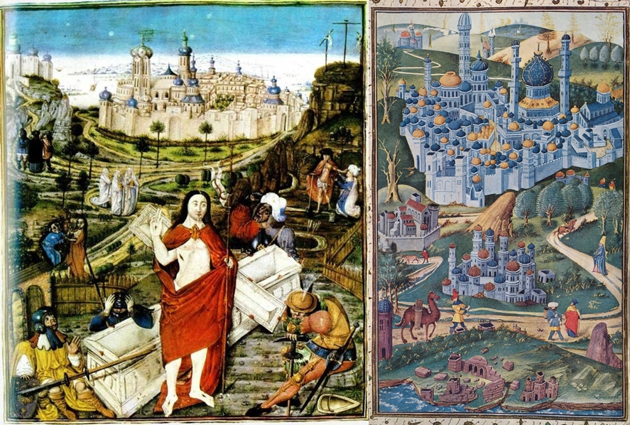
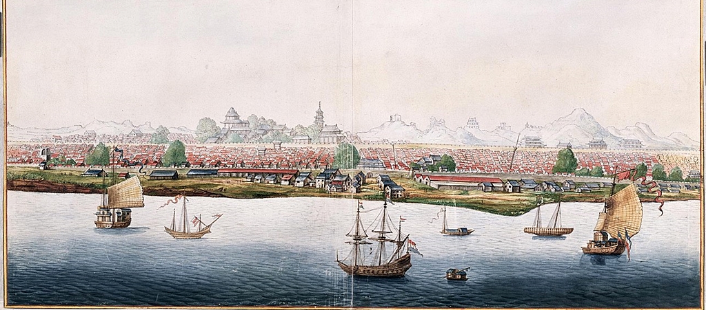
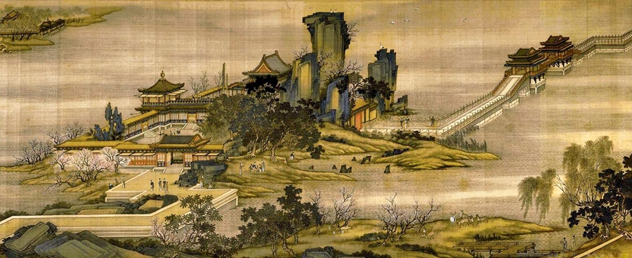
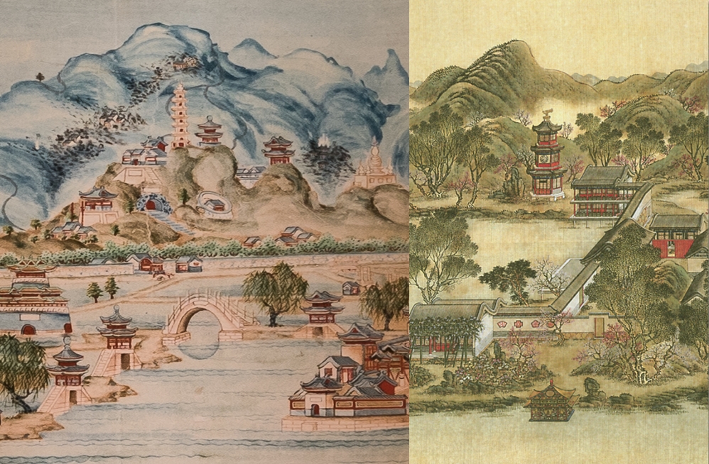
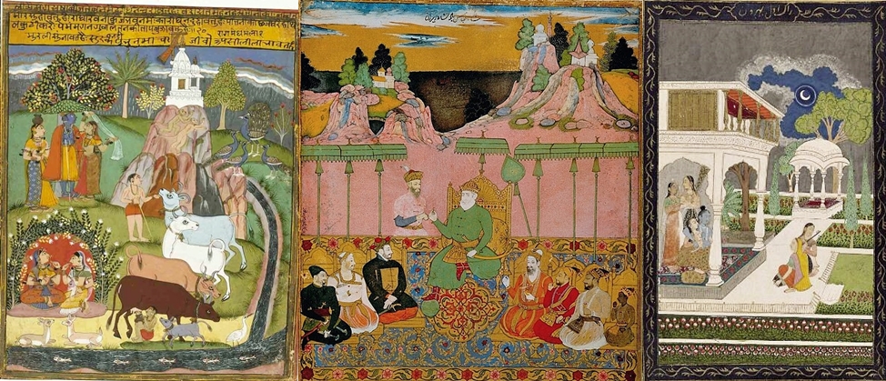
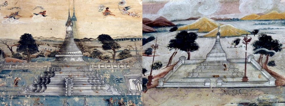
Asian Old Art:
Just a small selection of images showing old Japanese, Chinese, Indian and Myanmar art. Showing mud flooding and the melting of large buildings and building complexes.
China:
Japan:
India:
Below, we are just seeing the top parts of Old-World buildings in India, and look at the melted landscapes and partially melted buildings in the backgrounds. It is clear these artists were living in a mud-flooded and melted land:
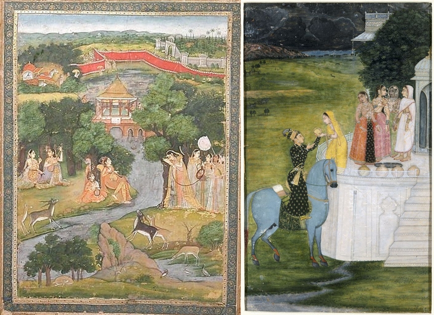
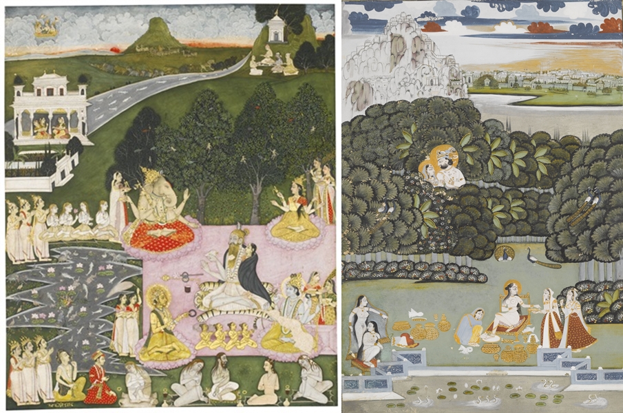
By the way, these Southern Asian people you see depicted in these images above are not people who currently live in India. These much taller, more robust and lighter-skinned people are the South Asian giants I refer to in other articles. I will have more images of them in a further article in the series.
Myanmar:
These images were painted on wall inside a temple. I could not find a definite date, but it is said to be some time around the 1700s. You can see that they are old pieces from the style and condition.
North Africa and Tartaria:
Before we move onto European Colonies I also want to bring your attention to some images from two other articles in this series. One: The illustrations by Nicolaas Witsen in the the late 1600s of towns or cities being obliterated and destroyed in the Tartarian Empire (Asia), Part 3 of this series. Two: The maps of North Africa from Part 8 of this series, that show many rivers, as well as some still standing Old World settlements, in Africa that no longer exist .
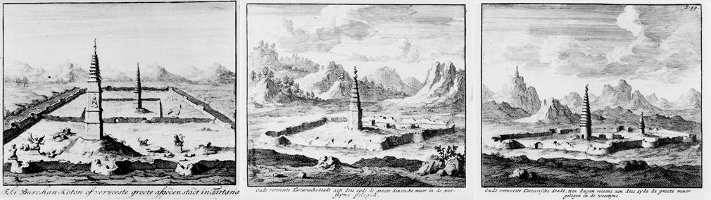
Larger versions of each of these images are in Part 3 and Part 8 of this series. These images above are reminders to make sure people correlate this information with the rest of the information in the current article.
Great destruction occurred in Tartaria in the 1600s and or 1700s. We know for sure that Tartaria was experiencing reset related events in the 1600s – and that at some point between 1618 and the late 1700s, or perhaps the very early 1800s, Africa experienced some more very severe destruction. These Old World buildings / towns / cities and rivers in the 1550 map were not mud flooded at later date, they were obliterated.
European ‘Colonies’
When attempting to put together a timeline it is important to recognise the spread of the Northern and Central Europeans around the world – which does not look to have been a natural organic expansion. It very much seems to have been planned and instigated by ‘The Powers That Be’. Back then there was not a White genocide agenda – that agenda and decision came later.
There are Old-World Buildings in North America, South Africa, Australia and New Zealand. And significantly they are what would be called ‘European’ Old World style buildings. For example, they weren’t Pagodas, Stupas and ‘Mosques’. So European people had to be sent to these locations so as to populate these Old World towns and cities for our latest reset to make sense (The reset that was ‘completed’ at some point in the 1800s).
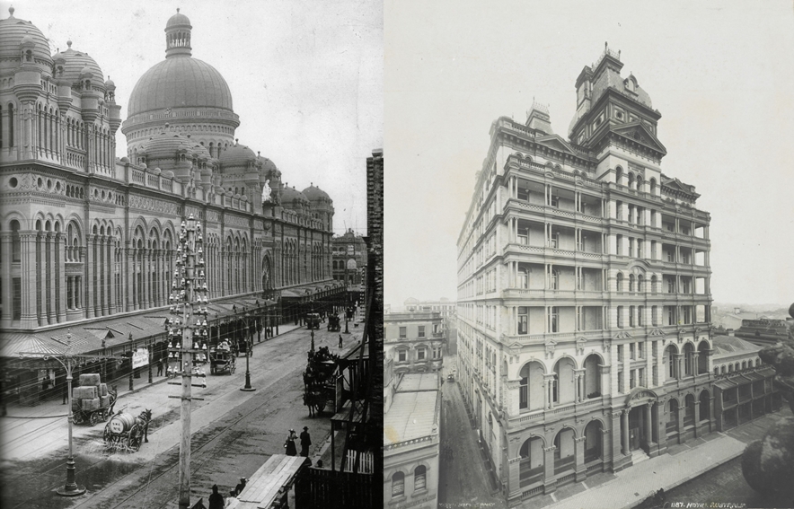
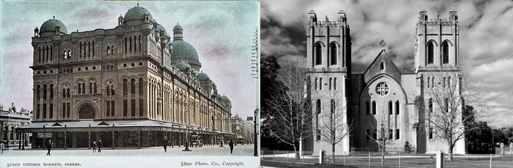
Australia – New South Wales (1788 – 1792)
New South Wales was founded in 1788, by the British who set up a small colony which became known as Sydney Town, and grew into the city of Sydney.
Some of New South Wales Old-World Buildings:
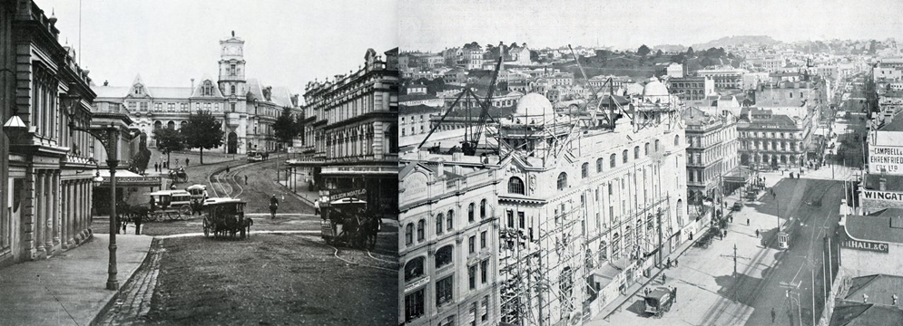
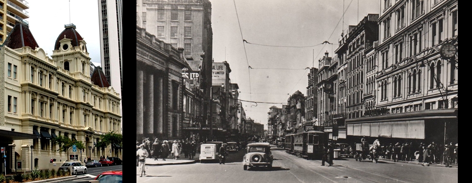
New Zealand – (1815 – 1823)
In Rangihoua Pā ti is said that the first full blooded European infant was born in 1815 at Oihi Mission Station near Hohi Bay. Kerikeri was founded in 1822. Bluff in 1823 claimed to be oldest European settlement. This area is just North of Auckland.
Some of Aucklands Old-World Buildings:
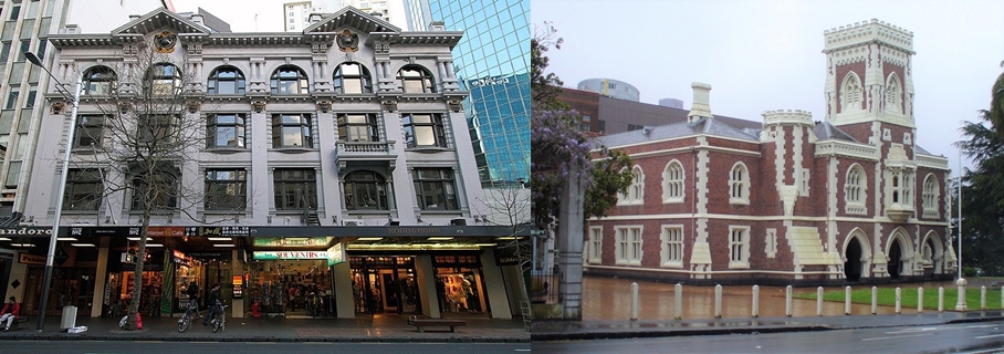
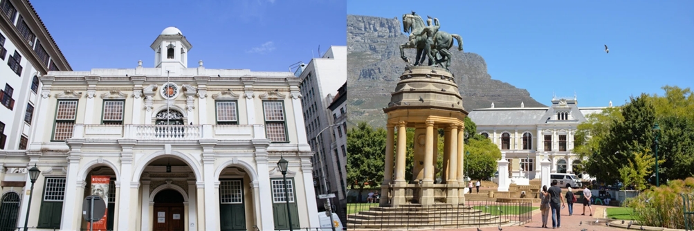
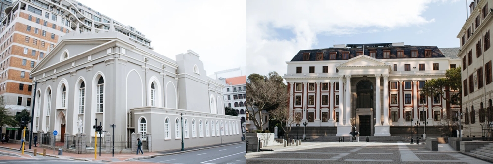
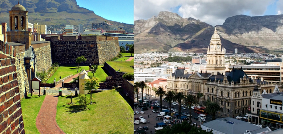
South Africa – Cape Town (1652)
Jan van Riebeeck ‘s arrival on 6 April 1652 established the VOC Cape Colony, the first permanent European settlement in South Africa.
Some of Cape Town’s Old-World Buildings:
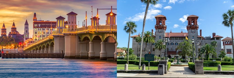
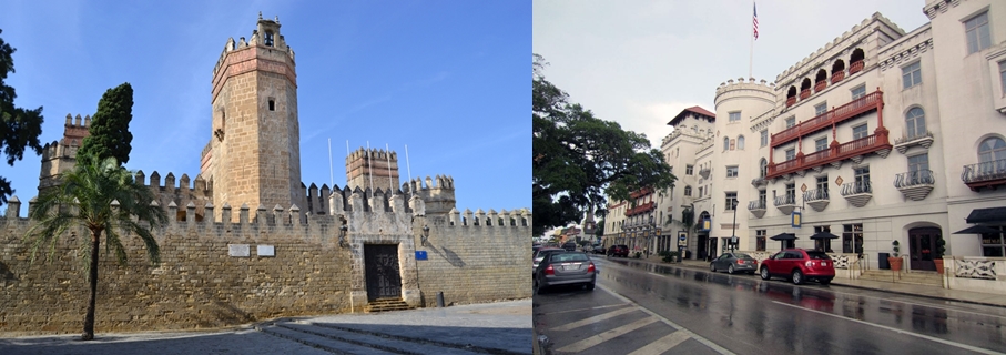
North America – Jamestown St. Augustine, Florida (1565) – Jamestown 14 May (1607)
St. Augustine, Florida was founded in 1565 – 42 years before the English colonized Jamestown and 55 years before the Pilgrims set foot on Plymouth Rock – making it the oldest continuously occupied European settlement on the North American continent.
All these Old-World Buildings would have already been in these locations when the Europeans arrived… all of them. Europeans have been purposely sent there, as it would be easier to explain away the architecture there. I do not think these expansions were organic natural occurrences. The Powers That Be obviously wanted Europeans to go to these regions as there was ‘European style’ Old Word architecture there.
It is hard for us to get our heads around the idea that this is not mentioned in our history. How could we forget this? Or how were the first civilians convinced that these Old World buildings were built by the European settlers? Why are there no records of humans discovering these large buildings and towns?
Were ‘The Proxies’ on Earth, aware that these buildings were already there? I most definitely think so. In Part 4 of this series, I looked at the accounts / books of the New World Explorers in the 16th century. I found clear evidence that these Old-World Cities were already in the Americas.
Jamestown
Let’s look at Jamestown as a small case study – though St Augustine also lays claim to being the first European Settlement, it is Jamestown in Virginia that we hear so much about.
We have established in previous articles (Part 1 in particular) that we smaller humans did not build these large stone Old-World buildings / towns. And that they have been built for a long time.
Just north of Jamestown is the town of Richmond, and just south of Jamestown is the town of Norfolk. Here is a map.
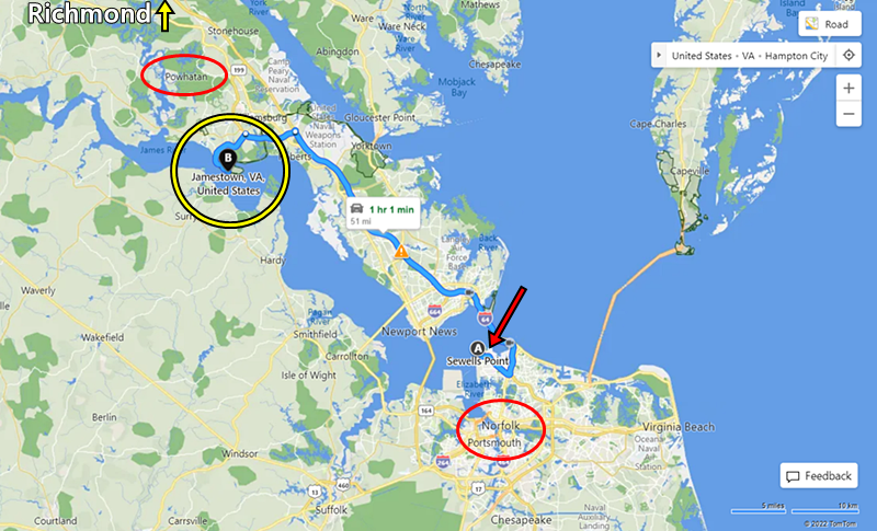
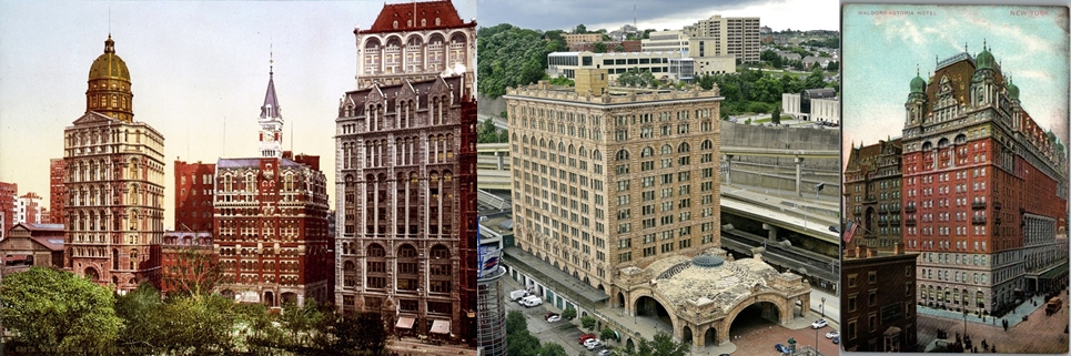
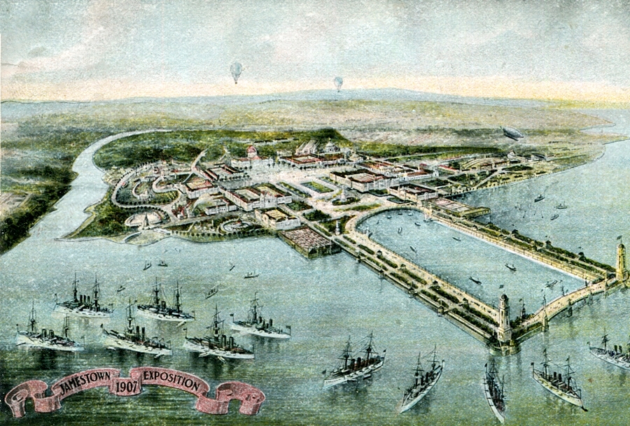
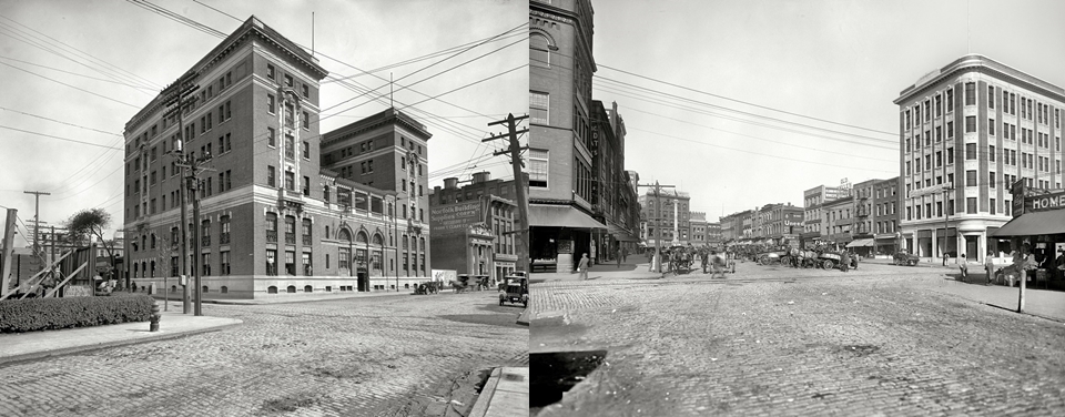
To get to Jamestown via the ocean you need to pass Sewells Point – and this is significant as an exposition was held at Sewell’s point in 1907 to celebrate the 300th year of the Jamestown’s settlement. Look at the buildings at this ‘exposition’ in the image below. In Part 9 of this series, I show how these Old-World buildings at these World Fairs and Expositions were not built by us and these events were there to explain away these already existing complexes of impressive stone buildings, and to mind control and influence the public. These buildings at this Jamestown exposition were already there. These people with horse and cart did not build all this – it is impossible.
As shown on the map, to get to Jamestown by boat you would have passed this complex. This complex would be visible to any ship passing by. But no one thought to mention this huge complex of Old-World massive stone, brick and concrete buildings to us?
Not only that, but there were already Old-World buildings at the two nearby towns of Richmond and Norfolk. Just a small selection below:
Norfolk, Virginia:
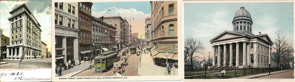
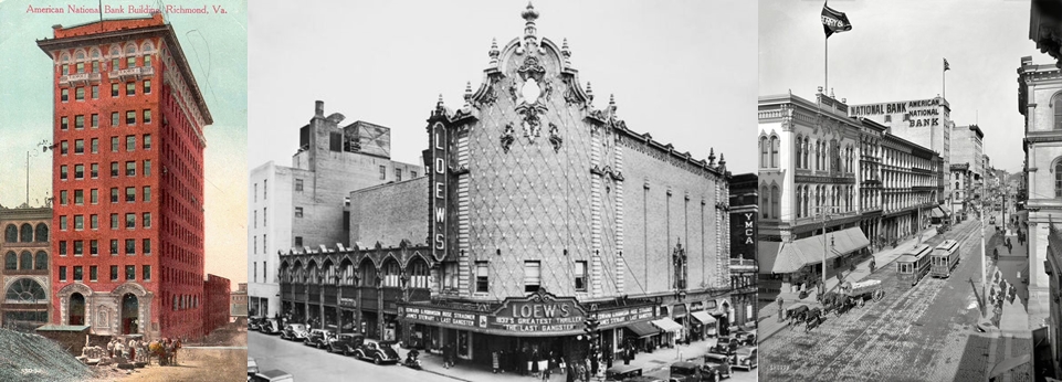
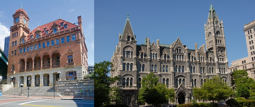
Richmond, Virginia:
If people had been settling in the area since 1607 how could they have not seen these buildings already constructed, in both the two nearby towns, as well as this complex of buildings at Sewell’s point, which were used for the ‘exposition’?
There were streets full of large stone buildings already in these locations of Richmond and Norfolk – as well as very large individual buildings. ‘The Powers That Be’ must have moved people into these towns and convinced them that the first European Settlers had built them… but they definitely had not built them – completely impossible. Did they ‘convince’ them – or did something more ‘far out’ or metaphysical occur? Later articles in this series suggest this is a possibility.
New World Explorers – North and South America
To show you that without a doubt these European Settlers did not build these Old-World buildings in North and South America, and that they were already there, we can look at the illustrations in the books documenting the explorations of the New World. Books documenting the exploration of North America, South America and the surrounding Islands in the late 1400s, the 1500s and 1600s. Old World buildings and towns / cities were drawn in the illustrations. Which meant the explorers described them and documented their existence when they arrived at these lands. In some images these Native Americans (White Indians) were shown to be using these Old-World buildings.
Here are images from a variety of explorers testimonies and publications:
Hans Staden – De Bry. Many walled Old World cities found on first expeditions:
Gottfried and De Bry – Natives of South America using Old World Buildings:
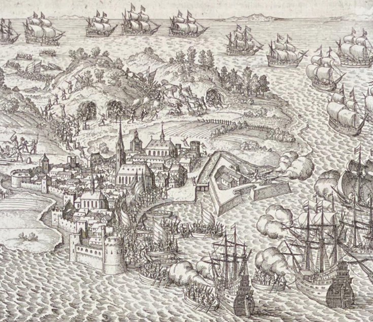
Gottfried and De Bry – Harbour and ‘fortifications’ attacked in South America in the 1500s:
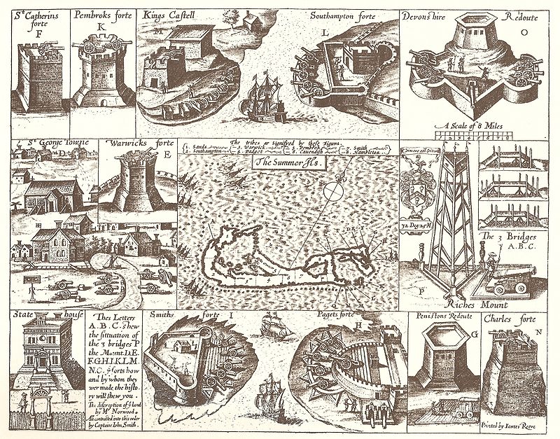
John Smith drawings of the Old World structures that already existed in Bermuda (The Europeans added the cannons – none of these structures were originally built for war):
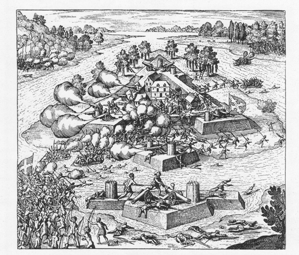
Rene Goulene De Laudonniere- La Moyne / De Bry – ‘Star Fort’ Old World stone ‘star fort’ walls found in the area of Florida. Europeans are seen building some wooden housing inside the already existing stone ‘star-fort’ walls:
Battle of ‘Fort’ Caroline. Using large stone star-fort walls for defence. Star-fort walls were not originally built as ‘fortifications’ by the Old-World builders – it is just what the European Explorers used them for when they found them:
The walled city the Incas were using when the Europeans arrived. Similar to many of the walled Old-World cities we see all around the world:
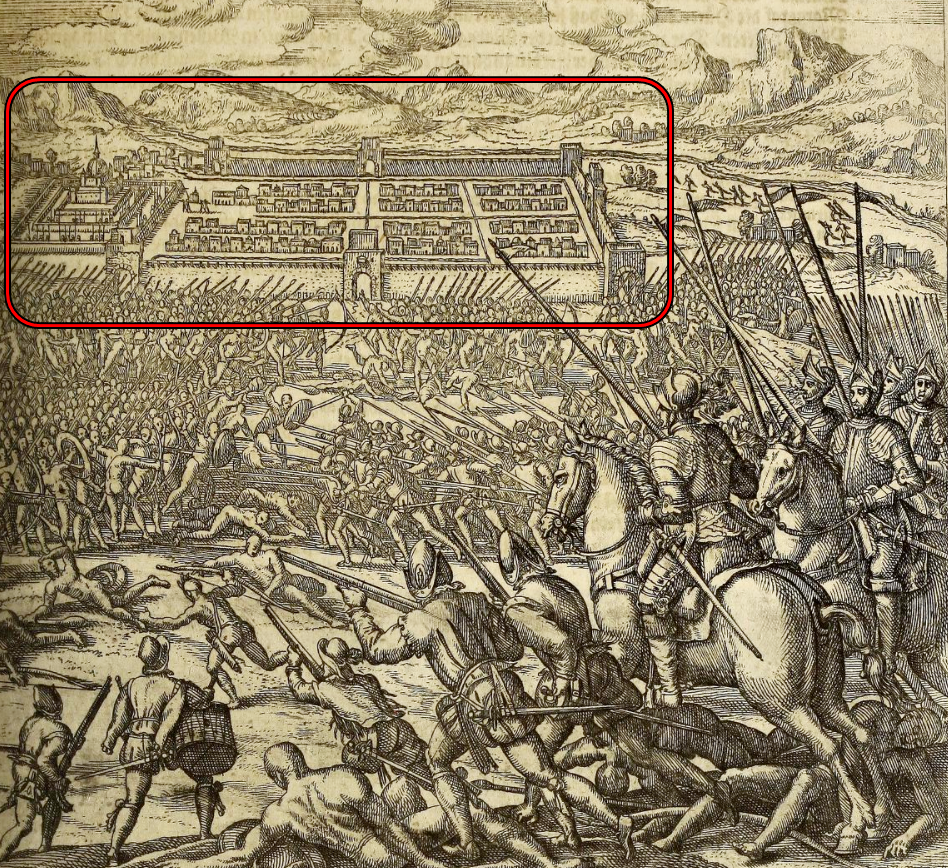
More images of Incas using Old-World buildings and being attacked inside their cities. A gallery – thumbnails, click to enlarge:
Gallery:
Note: After the last Website Update the galleries are all playing up. If it is not displaying properly, if you refresh the page twice (sometimes once) it will work just fine. I will endeavour to rectify this issue as soon as possible. 4 / 1 / 2023


All the Old-World buildings we see in South and North America were already there when the European explorers arrived in the late 1400s and throughout the 1500s.
Now consider the official so-called North American ‘native’ Indians (the small, skinny, dark-haired, brown skinned people), who were said to have been in North America long before Jamestown. Why had they not discovered these Old-World towns and complexes that existed all over North America? Why are there no stories from them of these Old-World buildings towns and cities? If these small brown dark-haired Indians were as widespread as they say, they would have surely had discovered the huge, stone, Old World cities dotted all over North America and Canada during their wanderings and nomadic lifestyles? There are no stories from them about these large cites with stone buildings. If you have not seen Part 4 of this series you should read it – as it will show you that the Natives of North and South America were White people of various sizes, some the same size as us current Europeans – most were significantly taller than us – some were much taller than us. There is actually no reference to, or illustrations of, the small dark skinned, dark-haired ‘native’ Indians of North America, or the small dark skinned, dark-haired people of South America from the New World explorers. Where did these people come from and how long have they really been in those lands?
Religion
Another factor to consider, when assessing some sort of timeline, is religion. Religion was created to to subvert the remaining giants and the smaller humans… and it would eventually subvert the added populations of smaller humans as well, when they inherited some of the Old-World cities in the 1800s. Because, as you will see in my next post, these Old-World buildings were all related to harnessing, manipulating and amplifying the invisible beneficial electric energy (solar particles from the Sun) that is all around us. It shows how they harness the beneficial electric ‘chi / prana / vril’ energy out of the atmosphere. And how cathedrals and churches were originally buildings / devices that created and sent out powerful frequencies to heal and raise consciousness. We see that the cross and crescent, on both churches and mosques, were really just the antennas at the top of the domes and steeples – they were there to harness the atmospheric electric energy that is all around us. Electric energy (tiny, electric, solar particles that come to use from our Sun) that is more prevalent in the upper portions of our atmosphere.
Just a brief overview of the religion’s inceptions / beginnings with rough dates (official mainstream narratives):
Origins of Hinduism: Most scholars believe Hinduism started somewhere between 2300 B.C. and 1500 B.C. in the Indus Valley, near modern-day Pakistan.
The history of Buddhism spans from the 6th century BCE to the present. Buddhism arose in Ancient India, in and around the ancient Kingdom of Magadha, and is based on the teachings of the ascetic Siddhārtha Gautama. The religion evolved as it spread from the northeastern region of the Indian subcontinent throughout Central, East, and Southeast Asia. At one time or another, it influenced most of Asia.
Judaism originates nearly 4,000 years ago in the Middle East with a couple named Abraham and Sarah, whom God selected to start a new people, the chosen nation. ‘God’ (yahweh) commanded them to relocate to a new land (which would eventually become the Land of Israel) that He would show them. In exchange for their devotion, ‘God’ promised Abraham that they would be blessed with many children and that they would be a source of blessing for others as well…. Most Jewish and academic sources define Judaism as the religion of Abraham, along with all its developments since that time. The life of Abraham is generally dated to around 2000-1700 BCE.
Christianity started about 2000 years ago in Judea (present-day Israel) with Jesus Christ and His faithful group of disciples. During this period, Judea was a cross-cultural mecca of bustling cities and farms. The emperor of Rome was the ruler. The Jews at that time hated Roman rule. The polytheistic cultural beliefs of Rome were also pagan and intrusive to Jewish life.
The religion of Islam began in the 7th century when the prophet Muhammad received revelations from God and wrote them down in a book that would come to be called the Qur’an. Muhammad began teaching what he had learned from God, and the community began to follow him because he led by example from what he believed he had learned.
- Hinduism — 2300 B.C. and 1500 B.C.
- Buddhism — 500 BC
- Judaism — 2000-1700 BC
- Christianity — 0 BC
- Islam — 600 AD
These are the approximate official dates. Do not fully trust them all though.
All religion was created to control us and subvert us in a variety of ways. Very significantly, it was also created to give us new stories about these Old-World buildings. Energetically powerful Old-World buildings became places of worship for Jesus, Yahweh, Buddha, Hindu ‘gods’ and Mohammed. Religion was created (as well as for other reasons) so that we did not discover what these Old-World buildings were really for, and that we humans are electric beings living in an electric universe – and that these Old-World buildings were helping to harness this very beneficial electric (chi / prana / vril) energy and bring it into our bodies. The next article in this series will look at this energy harnessing topic more closely.
Concluding Thoughts
We can say without a doubt, that there was not one massive, worldwide mud flood in the 19th century that destroyed the Old World civilisations! This ‘theory’, that exists out there in ‘the land of the internet’, is from lazy researchers or controlled agents muddying the waters and subverting people. I know I have mentioned this a fair few times now, but you will understand why I do, and you will be grateful, if you ever listen to all the so-called ‘mud-flood / Tartaria’ content creators on YouTube.
From looking at parts 5, 6 and 7 of this series, we can see the main and most significant destruction of the Old World civilisations was accomplished with both mud flooding and the melting of buildings – and that it happened a great deal further back than 150 – 200 years. From the art we can see that it was almost certainly before the 1400s, and the creation of religion suggests it was actually a long time before that (Unfortunately the artwork we have available to us from before the very late 1300s is almost useless – this suggests that there were was another large reset and some significant reset type events in the Dark Ages).
From all this artwork we can also see clear evidence that there was a systematic, ongoing, incremental destruction of the Old World cities / towns / buildings / infrastructure.
We can also see that there were Old World cities, towns and buildings already in Australia, New Zealand, South Africa, North America and South America before the 5 foot-tall-plus Europeans arrived and that this information has been hidden from us.
As with all articles in this series, if you have any additional information related to this topic, or any new insights from your own analysis, please share it in the relevant comments section. If something is not totally clear, let me know and I will try to help.
Additional Images:
- Star Fort Distribution Map (Atlantis)
- Nuremberg Chronicles Maps Gallery
- Additional Images from 1500s, 1600s and 1700s
- Saint Malo Case Study
- ‘Star Forts’ Then and Now
- More ‘Star-fort’ maps
Star Fort Distribution Map
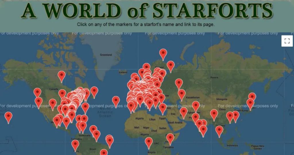
(I was going to save this distribution map until Part 14 but I will bring it to your attention now and then include it again in Part 14 – as I don’t know how long it will take for me to finish Part 14)
Look at this ‘star fort’ map above that someone has compiled. It obviously will not have all of them on it, as many ‘star fort’ towns and cities and ‘star fort’ walls have been destroyed or covered over – and certain regions like North Africa, and some areas of Canada, North America and South America, have been completely obliterated, but we can very clearly see some patterns.
Look at them all bunched up on the Atlantic coasts of Europe and the Americas. I would wager there would have originally been a great deal more in the coastal regions of North Africa before that region was obliterated, as well as more on the Atlantic coast of Canada and the northern region of South America. We can see that the spread of ‘star forts’ stops quite abruptly at the desert region of North Africa – as this is an area that was very thoroughly destroyed and turned to dust and sand.
The map alludes to there previously being some sort of focal point land mass in the Atlantic Ocean. It suggests a significant island / land mass may have ‘gone missing’ / been obliterated. This island would have been the fulcrum / centre of this White Old World Civilisation (Led by White Giants). It suggests Atlantis would have very likely been an island full of impressive Old World buildings. It also suggests that the island of Atlantis, and the main city on that Island, would have had ‘star fort’ walls and ‘star fort’ canals. If you were an invading force, then tactically it would make sense to destroy the fulcrum / centre / capital of the largest civilisation on the planet.
Through my research for this Resets and Genocides series I have discovered that we have been given a lot of subversive rhetoric on Atlantis – and controlled agents / authors were also seeded / created in the mid and late 1800s and early 1900s to gate-keep and control the narrative on Atlantis and many other subjects related to the history of our planet. The Plato rhetoric we were given was also controlled subversion – offering us a few truths, some half truths and some outright lies, just like most controlled opposition rhetoric does. I do not believe for one second that Atlantis was destroyed 10,000 years ago like Plato supposedly said – there is no way it was that long ago. A section in Part 14 of this series will revisit the topic of Atlantis.
Galleries:
Note: After the last Website Update the galleries are all playing up. If it is not displaying properly, if you refresh the page twice (sometimes once) it will work just fine. I will endeavour to rectify this issue as soon as possible. 4 / 1 / 2023
Nuremberg Chronicles Maps:


Additional Images from 1500s, 1600s and 1700s:


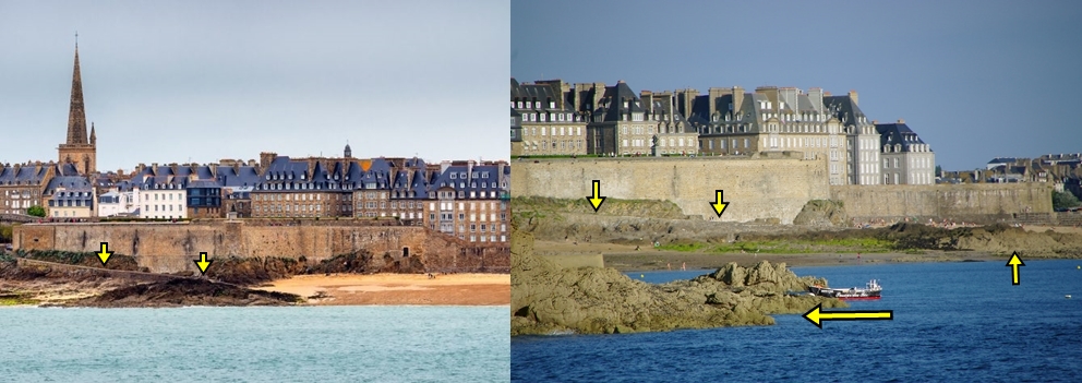
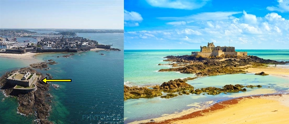
Saint Malo Case Study
I came across this illustration from the early 1700s and thought I would share a little analysis:
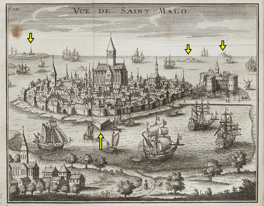
Above Image: Here we can see the coastal town with an encircling wall, but there would have been many more walls and attachments. We can see in the distance Old World buildings isolated on small rocky Islands, and we can see a remaining part of a ‘star fort’ wall at the front. The ground around the walls is very messy in this illustration. The expert and precise Old World builders would not have created this thin area of messy land.

All are Old World buildings in the town, with the healing and energising ‘cathedral’ in centre of the walled town.
Star Forts Then and Now:
In the first two comparisons it is difficult to see that there used to be ‘star fort’ walls and ‘stat fort’ canals there, but in the third and fourth we can see more of the arrangements.
More ‘Star Forts’:
‘Star-walls’ and ‘star-canals’ that did not make the main article.
More ‘Star-city’ / ‘Star-fort’ maps:
Thumbnails – click to enlarge


(Using Google Images you should be able to find larger versions of all of the maps in this gallery.)


Hi Entity,
Thank you for connecting the dots once more. I’m glad i found your site.
I live in Hulst, The Netherlands one of the star fort settlements as shown above. In fact: you can almost see my appartment building in the picture 🙂 I’ve always wondered how they managed to build those “defense walls” 500 years ago with shovels and barrows and only a couple of hundred people living in the area. Also there is a massive church in the centre of the town that doesn’t add up to the official story. I’ve been in there more then i should but i am going to have a look once more to see if i can find some clues.
Greetings, Dave
Hi Dave,
You are very welcome.
I like that you live in that ‘star fort’ settlement and that we can almost see your apartment – that made me smile.
And, yeah, there are illogical stories everywhere.
Best regards.
Hello E.A.
Thank you for all the wonderful research you do and all the insights about our present and past history. I have not seen before so many details about people and buildings and arts and maps depicting our past world from different periods.
I have been wondering if you have considered that time for us is circular and not linear as the PTB has described the history for us to swallow raw. A linear time parts our history into years BC and AD, so we shall press all our past into very narrow periods, Especially everything that should have happened and which existed during the last |000 years on continents that are even totally different from how they look like and are distributed now. It is quite remarkable and seemingly improbable to me.
The time as I have seen it for a while, occurs in episodes, ages, periods, eras, and eons for example. Each of these consists of stages representing a circle of history. The last Episode for example starts about 200 years ago (ca.1800-1820) with a Reset from the former Stage (Circle) within the same Episode. I call it Episode-1, and, as a though experiment, let’s say each Stage within Episode-1 lasts for about 200 years. But how many stages of 200 years (time circles) have occurred in Episode-1? I have the feeling that our Realm, which our civilization, as we have experienced it, are represented by the time which passed from the ending of the last Glacial Period 12000 years ago until now. In that case Episode-1 consists of 60 stages of 200 years each.
This Episode-1 is an Inter-Glacial, which is the last one of about 40 Inter-Glacial Episodes(Episode no.1-40) , which the Ice Age consists of. So, the Ice Age can be called Age-1, which has 40 episodes each with about 60 (?) stages, i.e. altogether 2400 stages, which in our linear way of thinking represents ca. 3 million years, which on the Geological time scale corresponds to the Quarternary Period (or in this case; Age)
Correspondingly there are many Ages and Periods and Eras forming the Tertiary “period” on the Geological time scale. The Tertiary started at about 80 million years ago. There are a lot of continental displacements which occurred during that time which could explain the existence of Atlantis as a part of Africa and America before the opening of the Atlantic Ocean.
Continental distribution and appearances could explain many old maps taking into account continental movements. And it can explain many odd features concerning cultures, buildings and human appearances and the existence of Giants. Their origin can be millions and even 10’s or 100’s of millions of years ago.
Documentations and maps are preserved underground being protected from destruction during major and minor resets and during the frozen ages (disappearance of our Sun), when civilizations inside the Hollow Earth have taken care of them.
So, when they part the time scale into hundreds of years, 1000, 1100, 1200,….,1800, 1900, 2000, I believe most of these references represents the Tertiary period from 80 million years until the Ice Age began or during it.., Many old buildings have been rebuilt during our present episode, however without the cultures which were the original architects behind them. The Megalithic cultures for example, existed probably 40-50 million years ago when Giants had to be the originators of some of the buildings. During the Ages of the Dinosaurs,(200-100 million years ago), corresponding to the Jurassic- and Cretacious periods, normal Human foot prints are observed to have been formed contemporaneously with Dinosaur footprints.
Search for “Forbidden Archaeology”. No doubt human populations and civilizations have existed even from about 2 B.Y ago, and perhaps before that also. And the PTB knows to keep records, however distorting them a bit to fit their agenda to deceive us about their presented time line. However they also let us have some evidences and signs about the circular time idea if some want to find out the truth.
Sorry, but you may have been thinking about the circular vs. the linear time of course. Anyway it can be used to explain a history even comparing it to the geological time scale for the Earth. God did not Create the Earth to be uninhabited by any of His Creations. It took Him only 7 days to create all the living things. The Bible says that for God one day is like a thousand years. Even if it took Him 7000 years to finish the Creation, it is well within the whole of the Geological timescale from about 4.5 B.Y. ago.The earliest traces of humans as I have seen in literature has been dated to more than 2 B.Y. old.
Carl
Hello Carl
You are welcome.
I appreciate the effort you have put into this comment.
A crucial aspect to understand, and you many begin to see this if you read all of my Resets and Genocides series (the yet to be published Part 13 will help as well), is that the very advanced reptilians have been shaping this planet for a long time. Numerous resets. They have incredible technology and weapons. They can obliterate islands and continents (reshaping lands etc). They created humans (including the human giants) and were their gods. Civilisations rose and were destroyed by them. New ones were created. Landscapes and continents were shaped (though, of course, there was also natural changes as well). I don’t know exactly for how long they have been doing this.
‘God’ in the bible is Yahweh. He was a bipedal reptilian. I can imagine that indeed there may be some Truth to the idea that “for God one day is like a thousand years”, as the leading reptilians are multi-dimensional realm-hoppers that understand the mechanics of time and the other levels of reality. They have a very good understanding of the mechanics of the cosmos.
Don’t believe all the dates TPTB give us, by the way.
Hope that helped in some way.